
Post a comment on the text below
Surface water and groundwater bodies
In the context of the WFD, the 'water environment' includes rivers, lakes, transitional waters, groundwater and coastal waters out to one nautical mile (12 nautical miles for chemical status (i.e. territorial waters). These waters are divided into units called water bodies.
The EU Member States now have reported 13 400 groundwater bodies and 111 000 surface water bodies: 80 % of them are rivers, 16 % lakes and 4 % coastal and transitional waters (Table 1.1). All Member States have reported river and groundwater bodies. 23 Member States (all reporting Member States except Luxemburg and Slovakia) have reported lake water bodies, 14 Member States have reported transitional water bodies and 20 reported coastal water bodies. In the second RBMPs seven Member States have delineated 46 territorial waters i.e. water bodies from 1-12 nautical mile.
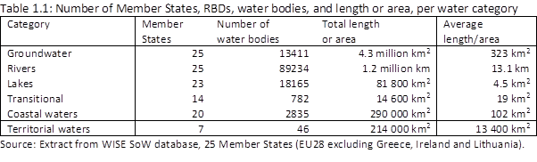
The number of water bodies varies considerably between Member States due to the size of their territory but also due to their approach to delineate water bodies. Sweden has by far the largest number of surface water bodies, followed by France, Germany, United Kingdom and Italy. Sweden and Finland show the highest number of lake water bodies. Coastal water bodies are the most numerous in Italy, Sweden and United Kingdom.
A similar disparity can be seen for groundwater bodies. France reported 30 % of the total groundwater area in the EU, and Germany and Spain 9 % each. Groundwater bodies can occur in different horizons, and some groundwater bodies overlay others. The average size of groundwater bodies also differs significantly. In Sweden and Finland, the average area is 7 km2, while in the other Member States the average area is nearly 700 km2.
Some Member States have re-delineated some of their water bodies for the second RBMPs. About 90 % of the surface water bodies are unchanged from the first to the second RBMPs. About 10 % have either been deleted, markedly modified (split or aggregated) or newly created. In most of countries, there were only minor changes in number and length/area of surface water bodies but in some Member States water body delineation has been completely revised and replaced by new groundwater surface water bodies.
The area of reported groundwater bodies was nearly the same for the first and the second RBMPs. Around 70 % of the groundwater bodies (by area) were not changed, while 29 % of the groundwater bodies from the first RBMPs were deleted and replaced by new groundwater bodies.
In the comparison of results from the first and second RBMPs EEA has in general only compared those water bodies that are unchanged or have only minor changes that do not hamper the comparison. For water bodies that have been deleted, aggregated, split or newly created, a comparison is not possible.
|
Further and detailed information on delineation of RBDs and water bodies is available in WISE: · Map RBMPs and relevant RBD statistics (update of 2012 map) · Surface water bodies: Number and Size; Number or Size, by Category · Groundwater bodies: Number and Size · Comparison of delineation of water bodies first and second RBMP: surface water bodies* · WISEevolutiontype – change in delineation of WBs: surface water bodies Link (details Link) and groundwater bodies Link (details Link) · CIS Guidance Document No. 2: Identification of Water Bodies Link |
* draft dashboards;
You cannot post comments to this consultation because you are not authenticated. Please log in.
Previous comments
First sentence: Please add another bracket at the end of the sentence: "....one nautical mile (12 nautical miles for chemical status (i.e. territorial waters)). "
"In Sweden and Finland, the average area is 7 km2, while in the other Member States the average area is nearly 700 km2." should be replaced as follows "In Sweden and Finland, the average area is 7 km2, while in other Member States the average area exceeds 1.000 km2."
"The number of water bodies..."
There are many differences among Member States regarding the setting of length of their surface water bodies. Therefore, benchmarking is quite difficult. For example: AT 2,7 km versus other big hydro countries FI, FR, SW, ES etc. approx. 10-12 km. However, there are not only difficulties in performing benchmark analyses but also in setting the "right" scale for measures.
"Map RBMPs and relevant RBD statistics (update of 2012 map)"
Ther is mistakes in that map. Finland has reported only two International River Basin Districts:
Tornionjoki IRBD (shared with Sweden)
Teno, Näätämöjoki and Paatsjoki IRBD (shared with Norway)
In the Table "Surface water bodies: Number and Size":
the length of the HU river water bodies is incorrect: it is not 19 313 km, but correctly 19 126 km and
the area of the HU lake water bodies is incorrect: it is not 1 017 km², but correctly 1 180 km².
"Table 1.1: Number of Member States, RBDs, water bodies, and length or area, per water category"
The total number of waterbodies (not including groundwater) in Table 1.1 (n=111062) differ from the total number stated in the Table ’Surface water bodies: Number and Size’ table (n=110950).
Better explanation of substantial differencies between member states GWB areas would be appreciated. In the meaning: Groundwater body area varies a lot from one member state to another because of between-states differences in the definition of the water bodies. Some countries have a simple 1-layer definition, sometimes restricted to the waterbodies providing drinking water. Some other countries such as France have a more accurate definition, including several depth layer. The former can have a reported GWB cumulated area lower than the country's geographical surface, while the latter can report a GWB cumulated area up to twice the country's geographical surface. For the next evaluation, it would be necessary to advance in homogenisation of GWB definition to ensure the relevance of between-countries comparisons (for exemple: decreasing the proportion of GWB areas/geographical surface for member states well covered and its increasing for anothers; using for exemple the boundaries of 0.8 to 1.4 )
p. 16 "The average size of groundwater bodies also differs significantly. In Sweden and Finland... 700 km2." We want to add that the reason is geological since the majority of the Nordic groundwaters are glaciofluvial.
Many Tables, maps and summary statistics to be updated.
"France reported 30 % of the total groundwater area in the EU, and Germany and Spain 9 % each." This very high figure for France is probably justified by the fact that to improve monitoring and management, FR has considered a large number
of horizons (whereas some countries have a simple 1-layer definition, perhaps even limited to drinking water supply)).
A clear comment is necessary to explain these figures / these discrepancies.