
Post a comment on the text below
For the purpose of this report, we have defined the potential floodplain extent as the lateral extent of a flood that has a return period of once every 100 years. As part of the Copernicus Land Monitoring Service, a riparian zone local component has been developed. It provides a high resolution geographical database of ecosystems found the riparian zone in Europe[1]. The floodplain area has been selected from this database, and has been used to calculate key statistics for EEA-39. Copernicus is a European system for monitoring the Earth using earth observation satellites and in-situ sensors (Copernicus, 2019).
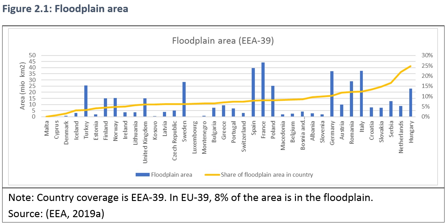
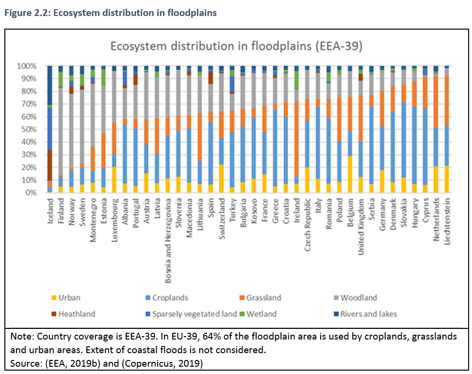
On average, 8% of the EU is covered by floodplain. Countries with more than 15% floodplain area include Slovakia, Serbia, the Netherlands and Hungary (Figure 2.1). The Scandinavian countries, Iceland, Norway, Finland and Sweden have less than 25% of their area covered by cropland, grassland and urban ecosystems, whereas in Germany, Denmark, Slovakia, Hungary and the Netherlands, more than 80% of the area is covered by these ecosystem types (
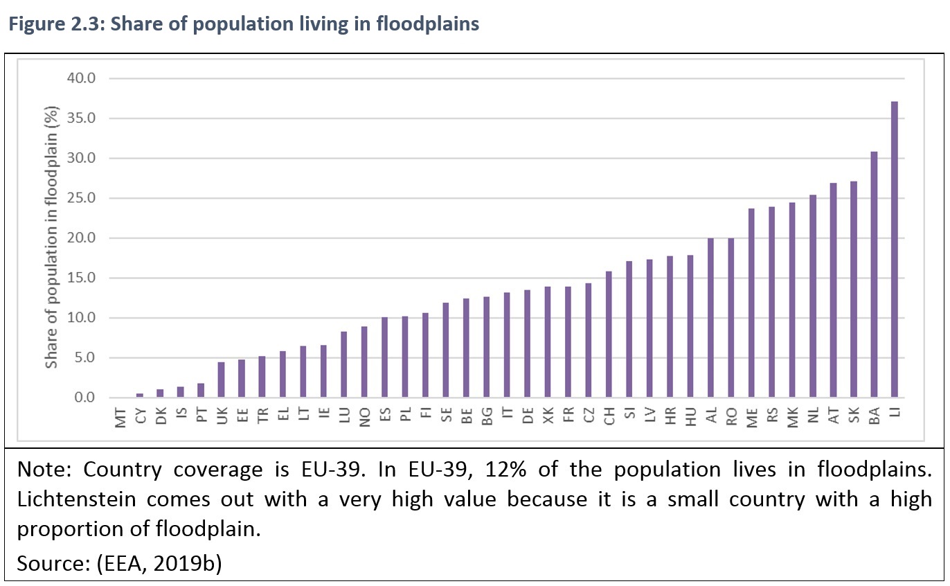
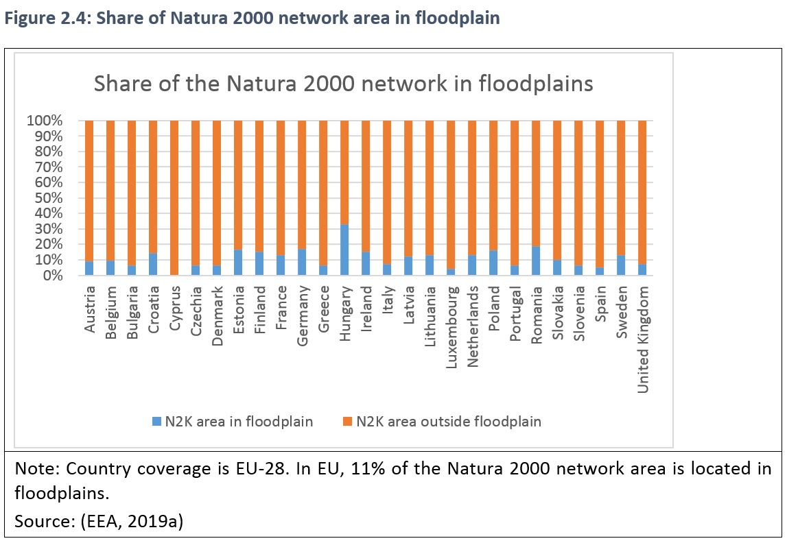
Figure 2.2). More than 25% of the population in Netherlands, Slovakia and Austria, Bosnia and Herzegovina, and Lichtenstein live in the floodplain (Figure 2.3). On average 11% of Europe’s Natura 2000 area is in floodplains, with Hungary having designated the largest share of the network in the floodplain. Natura 2000 sites are designated for protection of species and habitats listed under the Habitats and Birds Directives.
[1] The riparian zone product provides a detailed land cover dataset of ecosystem types in EEA-39 countries (Copernicus, 2019). Approximately 525.000 km² is mapped, covering rivers of Strahler level 3 to 8 with 100m grid size (GAF, 2015). The floodplain ecosystems are classified using eight MAES ecosystem types (EC, 2014). At level 1, the eight ecosystem types are: urban, croplands, woodland and forest, grassland, heathland and scrub, sparsely vegetated land, and rivers and lakes.
You cannot post comments to this consultation because you are not authenticated. Please log in.
Previous comments
Why do you provide the information about cropland, grassland and urban ecosystems in this chapter? I found this a bit distracting.
Figure 2.1: Is this depicting the "natural floodplain area"? I guess so, thus please state so.
Figure 2.3: Use full country names instead of abbreviations (to be in line with the other figures).
Third sentence: I guess a word is missing.
' It provides a high resolution geographical database of ecosystems found in the riparian zone in Europe'
Fourth sentence:
'The floodplain area has been selected from this database, and has been used to calculate key statistics for EEA-39.'
For figure 2.1 one or two sentences more should be added as it is not clear in the first view. Maybe first start with a sentence about floodplain area (countries with large and small), then one about the share (examples for >15% and an example for less) because both is shown in the figure.
In general, the text should give a little more than single result sentences. And the difference between EEA-39, EU-39 and EU-28 is not clear.
I don’t like the topic and term ‘ecosystem distribution’ for figure 2.2 as e.g. ‘urban’ and ‘cropland’ are not (natural) ecosystems. It may lead to misunderstanding, especially when you point out the not natural land use categories in the text. Maybe you could use the term land cover?
The text part should introduce the reader to following main topics. Maybe with one introducing sentence before giving details:
‘Within the floodplain area, European countries strongly differ in their land cover types, population density and share of Natura 2000 networks. The floodplains of Scandinavian countries, Iceland, Norway, Finland and Sweden are mainly dominated by woodland, whereas in Germany, Denmark, Slovakia, Hungary and the Netherlands, more than 80% of the area is covered by cropland, grassland and urban ecosystems (Figure 2.2). Concerning population density (Figure 2.3), floodplains of Netherlands, Slovakia, Austria, Bosnia and Herzegovina, and Lichtenstein are most densely populated with a share of more than 25%. Natura 2000 sites are designated for protection of species and habitats listed under the Habitats and Birds Directives; 11% of all Natura 2000 sites are located in Europe’s floodplains. The share of Europe’s Natura 2000 area in floodplains (Figure 2.4) ranges from xx to xx% whereas Hungary has designated the largest share of the network in the floodplain (xx%). For all other countries the share is < 20%.’
This is only a recommendation for the text.
For the purpose of this report, we have defined the potential floodplain extent as the lateral extent of a flood that has a return period of once every 100 years - Feasible definition but does this definition match with the Copernicus definition of flood plains - I don't think this is the case. As far as I know Copernicus only covers parts of your potential floodplain extent. Propose to highlight this explicitly
Fig 2.1. Use of a line to represent "share" of floodplain suggests there is a connection between countries, there is not and a separate bar woudl be more appropriate. Also "proportion" rather than "share" might be a better definition
Para 2. "Iceland, Norway, Finland and Sweden have less than 25% of their area covered by
cropland, grassland and urban ecosystems, whereas in Germany, Denmark, Slovakia, Hungary
and the Netherlands, more than 80% of the area is covered by these ecosystem types"
Do these figures relate to overall area of area of floodplains? - needs clarifying
Para 3. "On average 11% of Europe’s
Natura 2000 area is in floodplains,"
Is an average appropriate - and an average of what - presumably country by country, or is it Natura 200 sites. Maybe the total proportion of EU land is a more appropriate statistic?
If retain the average then specify if its country or site
Fig 2.5. confirm in map legend that the number is total floodplain habitats - not total habitats
"On average, 8% of the EU is covered by floodplain"
please clarify : Is 8% of the EU land area floodplain or is 8% the average proportion of the land area within member states which is floodplain.
NI. Table 2.3 – useful if names of countries were included similar to other tables
POLAND
figure 2.2.: data for 38 (not 39) countries - no data for Malta
figure 2.4.: data for 27 (not 28) countries - no data for Malta