
Post a comment on the text below
2.1. Spatial reference units
The study was built on the ‘European catchments and rivers network system’ (Ecrins), i.e. a geographical information system of the European hydrographical sub-catchments organised from a layer of 104,684 so-called ‘Functional Elementary Catchments’ (FECs) with an average size of about 60 km2 (EEA, 2012). The FEC-level represents the spatial unit at which all data used in this study were processed. All data referring to different spatial units (e.g. NUTS or E-HYPE sub-basins) were transferred into FEC-level (see Globevnik et al., 2017).
2.2. Existing landscape classifications
Two existing landscape classifications were influential to this study: (1) Six different agricultural land systems (derived from the “Land-system Archetypes” of Levers et al., 2018) and (2) four major European agricultural regions (derived from the biogeographical regions of the Habitats Directive of the European Community; Roekaerts, 2002).
The “Land-system Archetypes” developed by Levers et al. (2018) were defined at the pan-European scale (covering EU-28, except Croatia) on the basis of selected land-use indicators (e.g. various agricultural or forestry land cover, fallow farmland, nitrogen input, livestock density) representing the conditions in the year 2006. These archetypes describe landscapes featuring similar patterns of land cover and management intensities related to farming and forestry. Management intensity is classified by indicators of input-intensity (nitrogen application rates, livestock stocking densities) and output-intensity (amount of harvested biomass). The “Land-system Archetypes” were aggregated into six agricultural land systems characterised by type of land cover and management intensity: intensive and extensive cropland, intensive and extensive livestock, extensive grassland and fallow farmland. Management intensity classifies the material and labour input and harvest yield output, generally separating between intensive and extensive agricultural land systems.
Four major European agricultural regions were delineated to be used in all subsequent analysis: Western, Eastern, Mediterranean, and a combination of Northern and Highlands. This classification is framed by the biogeographical regions in Europe (Roekaerts, 2002) grouped into four major regions matching the geographical intercalibration groups relevant in ecological freshwater status assessment (Poikane et al., 2014). It considers the coarse climatic and socio-economic differences between the areas, which influence the agricultural land systems: The Western area generally exhibits favourable climatic and economic conditions for productive agriculture, while the Eastern area is still characterised by less-favourable conditions for historically and socio-economic reasons. Climate-induced water scarcity is the decisive factor in the Mediterranean, and the Northern and Highland areas are largely less-favourable areas for agricultural production due to wet and cold climatic conditions (Metzger et al., 2005; Kuemmerle et al., 2008).
Figure 2 shows the distribution of different agricultural land systems across Europe, for which the management intensity was quantified combining nitrogen input, livestock density and harvested output (Levers et al., 2018), together with the major agricultural regions of Europe.
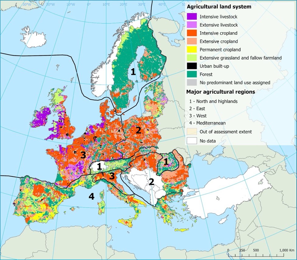
Figure 2: Agricultural land systems distributed across four major agricultural regions in Europe. The map shows the dominant land system per FEC (see text for details).
You cannot post comments to this consultation because you are not authenticated. Please log in.