
Table of contents
- Guidance to reader
- General comments
- Executive summary
- 1 Introduction
- 1.1 Aims of this report
- 1.2 Policy context
- 1.3 Structure of report
- 2 Status and pressures of Europe’s waters in 2nd RBMPs
- 2.1 Improvements in monitoring and assessment
- 2.2 Surface waters: Status and pressures
- 2.3 Groundwater: Status and pressures
- 2.4 Overall progress since the first RBMPs
- 3 Selected European key water management challenges
- 3.1 Pollution
- 3.2 Hydromorphological pressures
- 3.3 Abstractions and water scarcity
- 3.4 Aquaculture
- 3.5 Invasive alien species
- 4 Cross-cutting issues for European key water management challenges
- 4.2 Coherence of EU policy targets and management responses
- 4.3 Coherence of sectoral strategies with water policy objectives
- 4.4 Funding of measures
- 4.5 Measures with multiple benefits
3.2 Hydromorphological pressures
For decades, humans have altered the shape of water bodies and the flow of river courses to farm the land, facilitate navigation, construct hydropower plants and protect settlements and agricultural land against flooding. For these purposes, rivers have been straightened, channelised and disconnected from their floodplains; land has been reclaimed, dams and weirs have been built, embankments have been reinforced, and groundwater levels have changed. These activities have resulted in altered habitats, changed flows, interruptions in river continuity, loss of floodplain connectivity and severe impacts on the status of the aquatic environment. These changes have caused damage to the morphology and hydrology of the water bodies, i.e. to their hydromorphology (EEA, 2018; EEA, 2019).
Hydromorphology plays a key role for aquatic ecosystems. For example, water flow and substrate provide physical habitat for plants and animals, such as fish and benthic invertebrates. Good hydromorphological functioning is an essential element of ecosystem health and underpins the delivery of many ecosystem services and benefits for society (EPA Catchments Unit, 2016; Houlden, 2018).[1]
[1] https://www.catchments.ie/hydromorphology-what-is-it/ and http://www.hrwallingford.com/news/Hydromorphology-the_forgotten_facet_of_the_WFD
In the second RBMPs, hydromorphological pressures are the most commonly occurring pressure on surface waters, affecting 34 % of all such water bodies (EEA, 2018). The most reported hydromorphological pressures are physical alterations related to flood protection, urbanisation, agricultural development and navigation as well as barriers including dams and weirs built for different purposes (hydropower, flood protection, irrigation, or navigation). In addition, several thousands of water bodies are affected by hydrological alterations driven by water abstractions (for public water supply, agriculture, or industry) and reservoirs used mainly for hydropower and irrigation. However, in the second RBMPs of most Member States, the identified hydro-morphological pressures are not clearly apportioned to specific drivers (EC, 2019).
Further, 16 % of European water bodies have been designated as heavily modified (13 %) or artificial (3 %) water bodies.
Key hydromorphological pressures are described in the following sections of this report elaborating on the role of hydropower, navigation, flood protection and agricultural drainage as major drivers of impacts on hydromorphology in Europe. Also, separate sections address the role barriers to illustrate their very dense distribution and far-reaching impacts on the European river network and key issues related to the loss of lateral connectivity to floodplains.
Certain aspects of hydromorphological pressures and impacts are less well-known so far in terms of their extent and implications on European scale. One of these aspects is the issue of changed sediment dynamics due to hydromorphological pressures which is gaining more and more attention and will require targeted management interventions in the near future (see Box 22). In the meantime, the issue should remain in focus of further data collection and research to identify the main underlying processes, impacts on water bodies and appropriate management approaches.
Box 2 Sediment quantity and hydromorphology
Sediment and sediment transport are essential and integral natural elements of the hydromorphology of rivers, lakes, estuarine and coastal systems. Sediment is also vital to the ecology of these systems, providing and supporting habitats as well as nutrients for aquatic plants, invertebrates, fish, and other organisms. Although the WFD does not explicitly take account of sediment, ecological status is clearly dependent on habitat (including sediment quantity) and clearer understanding is needed on the role of sediments in the WFD and related legislation such as the Floods Directive and Marine Strategy Framework Directive.
The management of most European rivers by humans has resulted in substantial modifications to natural sediment transport processes, sometimes with dramatic consequences for the stability of rivers and coastlines (SedNet, 2014). Dams act as a barrier in the hydrological system as they interrupt the continuity of sediment transport through rivers systems. Sediments trapped in reservoirs cause a deficit of sediments downstream reservoirs leading to erosion, morphological and ecological consequences in the downstream rivers (Kondolf et al, 2014). Also, the dredging of sediment, which is necessary to maintain and develop ports or navigable waterways, can increase tidal floods and damage ecology by directly affecting physical habitats, disrupting riverine processes and reducing connectivity with the floodplain (England & Burgess-Gamble, 2013).
The relevance of sediments for achieving fundamental management goals in river basins is obvious. However, the perceived complexity often hinders the full integration of sediment issues into river basin management (SedNet, 2017). The WFD takes a river basin scale approach to water management which is well aligned with the need to manage sediments at this scale, through the development of sediment management plans, rather than locally as has been the case traditionally. To date, most European countries though do not have sediment management plans in place (Dworak and Kampa, 2019).
Some major European river basin commissions have taken up the challenge to work towards transboundary sediment management plans as part of river basin management planning, such as the Rhine and Danube commissions (Brils, 2008). Also, in the Elbe, a comprehensive sediment management concept has been developed in support of management planning in a large international river basin, serving as an inspiring example on how to integrate sediment in river basin management (SedNet, 2017). A transboundary dimension to sediment management plans beyond national borders is important so that national plans are coordinated and have similar levels of ambition within transboundary catchments.
The WFD explicitly requires Member States to manage the effects on the ecological status of water which result from changes to physical characteristics of water bodies. It requires action in those cases where hydro-morphological modifications are having an impact on the ecological status interfering with the ability to achieve the WFD objectives and to avoid deterioration due to new modifications. The restoration of hydromorphological conditions can take place using a wide range of measures such as removing river obstacles to restore river continuity, setting ecological flow requirements, improving physical habitats in rivers and on their floodplains or implementing natural water retention measures.
At the same time, WFD measures for hydromorphological pressures should not be taken in a silo approach but it is beneficial, both in terms of the effects to be achieved and funding opportunities, to coordinate the planning of WFD measures with the planning process for other sectors (e.g. planning for the energy, transport and agricultural sectors) (EC, 2019).
3.2.1 Barriers
Overview
Humans have fragmented European water bodies with artificial barriers such as dams and weirs for centuries, as a means of ensuring water supplies, generating energy, facilitating navigation, and controlling flooding. Such human-made barriers reduce the ecological connectivity of a water body, impeding the flows of water, nutrients and sediment, create obstructions for species movement (particularly migratory species), often alter the quantity, quality and timing of river flows, both upstream and downstream, and can impact surrounding riparian zones and flood plains (Freshwater Information System, 2019).
There are different types of barriers, including dams, sluices, weirs, culverts, fords and ramp-bed sills and the extent differs to which these are recorded in the different national river assessment systems across Europe.
In the second RBMPs, barriers are a significant pressure for almost 30 000 surface water bodies (20 % of total) in WFD countries, with the highest numbers being reported in Sweden, Germany, Austria, France, Denmark, and Spain. Furthermore, barriers are the reason or one of the reasons for designating approximately 10 000 water bodies as heavily modified, which amounts to more than half of heavily modified water bodies in Europe.
A large number of barriers are reported in the RBMPs to be used for hydropower (dams for hydropower production), flood protection and irrigation (water storage reservoirs). However, for a large share of water bodies affected by barriers (ca. 40 %), the uses which the barriers serve are unclear, either being unknown or not explicitly reported or obsolete. Indeed, many barriers on European rivers originated in the 10th to 19th centuries to operate mills and a high proportion of these are by now redundant. It is estimated that alone in France, Spain, Poland and the UK, there are up to 30 000 mainly small dams which are now obsolete (Gough et al., 2018). In addition, there are many weirs without a practical use.
The most comprehensive overview of river fragmentation in Europe is provided by the recently published Pan-European Atlas of In-Stream Barriers.[1] The Atlas contains information on 630 000 barriers including not only large dams, but also hundreds of thousands of smaller weirs, ramps, fords and culverts. However, researchers have recently found that more than one third of barriers on European rivers are unrecorded, bringing the total to well over 1 million. This scale of river fragmentation is alarming and makes Europe the most fragmented river landscape in the world, with hardly any unfragmented, free-flowing rivers left (WWF, 2020). [2]
[1] Produced by the EU Horizon 2020 project Adaptive Management of Barriers in European Rivers (AMBER): https://amber.international/european-barrier-atlas/
[2] WWF, 2020, More than 1 million barriers destroying Europe’s rivers, new research shows, accessed 27th July 2020, https://www.wwf.eu/wwf_news/media_centre/?uNewsID=364559
Figure 7 Man-made river barriers in Europe included in the AMBER Atlas

Notes: Insert notes here
Impacts
Man-made barriers such as dams, weirs and other impounding structures typically have the following negative effects on the environment of rivers:
- Habitat loss: Natural dynamics and river habitats are lost upstream of dams as they are ‘drowned’ or suffer depleted flows downstream due to the alteration of water flow conditions. As a result, aquatic flora and fauna are dramatically altered (Gough et al., 2018).
- Flow regulation is one of the main adverse ecological consequences of dams and reservoirs to rivers. This is evident in downstream river ecosystems and is a result of dam operations reducing natural flows, eliminating peak flows, changing seasonal flow patterns, regulating low flows or other regulatory practices. Flow regulation may have significant negative effects on fish fauna and benthic invertebrate communities.
- Fragmentation: Rivers are transformed into a series of ponded sections; dams block migration routes for fish in both up and downstream directions and habitats are isolated through fragmentation. This transforms natural fish fauna and leads to local extinction of fish species (Gough et al., 2018).
- Sediment: Dams block transport of sediments in rivers, leading to accumulation and poor water quality in the reservoir, deprivation of sand and gravels downstream of dams, higher risk of erosion downstream of dams and in river deltas, and to a decrease in habitat quality upstream and downstream of the dam (Gough et al., 2018).
- Water quality: Storage of organic material and nutrients in reservoirs and also in backwater from smaller dams often leads to a decrease in water quality, changes in temperature and the capacity to dissolve oxygen, and sometimes to seasonal stratification (Gough et al., 2018). Ponded sections have a longer water residence time, thus enhancing eutrophication effects such as phytoplankton blooms.
The impacts of barriers vary according to the height and location of barriers. A major impact on a river could be caused by a single, very damaging structure or by the accumulated effects throughout the length of the river of a series of small structures, which may have only a small impact individually (EEA, 2018). The location of barriers in a catchment determines, to a large extent, their impacts on sediment fluxes, fluvial habitats such as floodplains and deltas, and on the abundance and diversity of freshwater biota. For example, barriers in lowlands can prevent or delay fish migrations, while headwater barriers can alter downstream flows and sediment transport (Jones et al., 2019).
The height of barriers also plays a major role in determining the impacts on freshwater biota and the surrounding ecosystem. High-head structures (large structures), typically higher than 8 m or 15 m, often create large impoundments, which can cause shifts in the composition of biota communities within the reservoir as well as downstream. Low-head structures (small structures) can also impact key ecological processes just as strongly. Because of their very large number, small structures are likely to cause greater cumulative impacts and a more significant loss of river connectivity than high-head structures (Jones et al., 2019).
Measures and management challenges
Already in the first RBMPs, several European countries planned measures to improve the ecological conditions of rivers impacted by barriers. The planning of measures in the second RBMPs indicated substantial further effort to improve longitudinal continuity in river basin districts. The most common measures planned in this respect include the building of fish ladders and bypass channels, the removal of artificial structures such as barriers, the setting of ecological flows and measures for sediment management.
The implementation of such measures is closely linked to the environmental objective of the WFD to restore continuity for migrating species in regulated rivers. A number of other EU policies are also supporting the restoration of river continuity and the rehabilitation of surface waters that are impacted by barriers, including the Birds and Habitats Directives (2009/147/EC and 92/43/EEC), the new EU Biodiversity Strategy for 2030 (EC, 2020) and the Eel Regulation (Council Regulation (EC) No 1100/2007). The new EU Biodiversity Strategy 2030 has actually included a specific commitment to restore at least 25 000 km of free-flowing rivers by 2030 through the removal of primarily obsolete barriers and the restoration of floodplains and wetlands (EC, 2020).
Overall, due to the very high number of barriers present on rivers in Europe, there is a need for prioritisation of measures to restore continuity. Some national and regional strategies for restoring continuity are in place to ensure a phased approach in dealing with the issue of barriers. Examples include the Benelux treaty on free fish migration (adopted in 1996), continuity restoration initiatives in the international river basins of the Rhine[3] and the Danube (Shepherd, 2012) as well as national programmes and priority networks for river continuity restoration in specific countries such as France, Austria, Germany and Finland (Kampa et al, 2017; Ollikainen & Vilhunen, 2019).
[3] http://www.salmoncomeback.org/
The implementation of measures is affected by significant gaps in knowledge concerning barriers, their abundance, distribution in the European river networks (especially of small barriers) and their ecological effects. Recent AMBER study (see above) might have summarised many of the needed basic information. Also, knowledge still needs to be solidified on the effects of some of the key measures. For instance, barrier removal is increasingly viewed as a necessary management measure to reinstate natural connectivity. However, we so far have little knowledge to make predictions about the geomorphological and biological trajectory of a river system once a barrier has been removed (Birnie-Gauvin et al., 2017). Also, knowledge is lacking on measures to mitigate impacts on downstream migration of fish at hydropower turbines especially in large rivers.
An additional implementation challenge arises from the large number of barriers with an unknown or obsolete use. Funding measures to make barriers with obsolete use passable is a challenge, because of the lack of a specific water use sector assigned to these modifications in the rivers.
In parallel to planning measures for dealing with the impacts of existing barriers, new barriers and dams are built elsewhere in Europe driven by policies for energy production, transport, flood protection and securing water supply (e.g. new hydropower plants in the Balkans, see WWF (2019))[4]. In this respect, a much closer coordination of river basin management planning under the WFD and the planning of new river infrastructure to serve sectoral development is essential to safeguard river continuity.
[4] WWF, 2019. Hydropower pressure on European. The story in numbers.
3.2.2 Loss of lateral connectivity (flood protection and drainage on floodplains)
Overview
Wetlands and floodplains play a particularly important role in the ecological integrity of aquatic ecosystems. By providing habitats for life stages of aquatic organisms, they are significant in ensuring or achieving the good ecological status of adjacent water bodies. Wetlands and floodplains also play a significant role in flood retention (EEA, 2018).
Studies have shown however that 70-90 % of European floodplains have been environmentally degraded as a result of structural flood protection, river straightening, disconnection of floodplain wetlands, agricultural land use and urbanisation over the past two centuries. The largest pressures on floodplains are linked to hydromorphological pressures, land use and pollution (EEA, 2019).
Flood protection structures play a key role in this context. Flood events are one of the most common and most dangerous natural hazards affecting European society with almost 3 700 flood events having occurred in Europe between 1980 and 2015 (EEA, 2016). Since decades, European countries have taken flood protection measures that mostly involve conventional engineering flood protection structures to mitigate the catastrophic consequences of floods. At the same time, flood protection structures and measures (such as levees, retention basins, channel straightening, removal of vegetation and sediment) are among the main causes for hydromorphological alteration and ecological impairment of rivers, in particular by disconnecting river channels from the floodplains and modifying riparian zones.
Further pressure on the river-floodplain system is exerted by activities that drain excess water from the soil to increase areas suitable for crop production. Land areas may also be drained to serve for forestry or coastal and urban development. Drainage for agriculture has led to major losses of wetlands throughout Europe and is related to several hydromorphological pressures such as channelization of rivers and channel deepening (Vartia et al., 2018). In Europe, 35 % of wetland loss between 2000 and 2006 was due to conversion to agriculture (EEA, 2012); only in south-western Sweden, almost 70 % of wetlands have been lost due to drainage over the last 50 years (Franzén et al. 2016). In many European countries mainly in northern and central Europe, more than 40 % and up to 100 % of farmland is being drained (based on data from ICID, undated).[5] [5] http://www.icid.org/imp_data.pdf
In the second RBMPs under the WFD, almost 15 000 surface water bodies (about 10 % of total) are affected by physical alterations of their channel, bed, or riparian area due to flood protection and/or agriculture in 21 of the WFD countries. In addition, flood protection and/or drainage for agriculture are the reasons for designating almost 7 500 water bodies as heavily modified in 26 European countries.
Impacts
Both flood protection infrastructures and drainage affect floodplains and the connectivity of rivers and streams to floodplains, as they cause changes to the land area surrounding water bodies. This can have major implications for the integrity of both riparian and aquatic ecosystems (Amoros and Roux, 1988; Junk et al., 1989, Junk and Wantzen, 2004). In a natural system, lateral connectivity between rivers and their floodplains allows the exchange of water, sediment, biota as well as nutrients. The loss of lateral connectivity leads to the loss of key habitats and as a result to the decline of species and biodiversity both on the floodplain itself and in the aquatic environment. Further, physical processes are disturbed related to the natural water retention capacity of floodplains as well as sediment dynamics.
Artificial bank protections that serve flood protection (embankments, levees or dikes) affect the morphology and dynamics of the river channel by restricting the channel width and the sediment supply from the river banks. Bank reinforcement and levee construction can also lead to bed incision because of the resulting high flow velocities; in its turn, bed incision reduces the connectivity between the river and its floodplain (lateral connectivity). The reduction of this lateral connectivity damages the functioning of the riparian zone and reduces productivity, nutrient exchange and dispersal of biota more widely across the floodplain.[6]
As far as land drainage is concerned, natural channels have been straightened and deepened for surface drainage ditches with significant effects on channel morphology, instream habitats for aquatic organisms, floodplain and riparian connectivity, sediment dynamics, and nutrient cycling (Blann et al, 2009).[7] Further, the regular maintenance of drainage ditches and rivers (via dredging and weed cutting) leads to physical disturbances and morphological changes in water bodies (Vartia et al., 2018).
[6] REFORM wiki “Embankments, levees or dikes“, available online at http://wiki.reformrivers.eu/index.php/Embankments,_levees_or_dikes#Useful_references
[7] https://www.researchgate.net/publication/241682569_Effects_of_Agricultural_Drainage_on_Aquatic_Ecosystems_A_Review
Figure 8 Embankments for flood protection (left) and agricultural drainage (right)
Photos not included in TalkBack
Notes: Insert notes here
Sources: Left photo on embankment (Rinaldi et al. 2016), right photo on drainage (Swedish Board for Agriculture & Swedish Agency for Marine and Water Management, 2015)
Measures and management challenges
The restoration of bank structures, the reconnection of floodplains or backwaters (such as oxbows and side channels) and the restoration of wetlands are key measures applied in river basin management planning to restore lateral connectivity between rivers, their riparian area and the wider floodplain (EEA, 2018). For example, in the international Rhine basin, about 125 km² of floodplains were reactivated by 2012 with a target of more than 150 km² by 2020. In addition, measures were taken to increase the structural diversity of approximately 100 km of river banks by 2012 with a target of 800 km of banks by 2020 (ICPR, 2015). With increasing awareness on the importance of floodplains, the numbers of examples of restoration measures or works aiming to improve river-floodplain systems' functioning are rising (EEA, 2019).
The improvement of lateral connectivity between rivers and their floodplains is a key element for the achievement of the environmental objectives of the WFD. Especially multi-benefit measures which support the achievement of environmental requirements of various environmental policy instruments beyond the WFD, such as the Floods Directive, Birds and Habitats Directives and the Nitrates Directive are particularly relevant to the restoration of disconnected wetlands and floodplains. For example, buffer strips can be beneficial for reducing pollution (included in the Nitrates Directive and the good agricultural and environmental conditions of CAP cross-compliance), for improving riparian habitats, reducing hydromorphological pressures as well as increasing water retention and mitigating the impacts of floods.
River restoration measures aiming to give more room to rivers are also important for floodplain restoration as well as for the prevention of flood disasters. A targeted ‘Room for the River’ Programme was established in the Netherlands, consisting of over 30 projects that were completed at the end of 2018. The key of the Room for the River approach is to restore the river’s natural floodplain in places where it is least harmful to protect those areas that need to be defended from floods.[8]
It is difficult to predict how exactly pressures on European floodplains and lateral connectivity of rivers may develop in the future. Climate change though, in particular in northern Europe, is bound to lead to increased precipitation and flood events. In its turn, this may require further mitigation measures linked to flood defences as well as increased drainage leading to increased pressures on floodplains and lateral connectivity (EEA, forthcoming).[9] At the same time, European targets of the new Biodiversity Strategy need to be met, whereby the restoration of floodplains and wetlands is mentioned as a means for restoring at least 25 000 km of free-flowing rivers by 2030 (EC, 2020).
Despite the obvious importance of floodplain restoration, it has not been systematically included in river basin or flood risk management plans yet. For developing more strategic approaches to floodplain restoration in the future, it will be important to develop a more coherent knowledge base on floodplains and a more targeted approach towards financing this type of restoration (EEA, 2019).
[8] https://www.dutchwatersector.com/news/room-for-the-river-programme
[9] EEA, forthcoming, Water and Agriculture report.
3.2.3 Hydropower
Overview
Hydropower has a long history in Europe and currently generates around 10 % of the European net electricity (Eurostat, 2019) and more than one third of renewable electricity in EU (in 2015, based on Eurelectric & VGB Powertech (2018)). Norway and Switzerland are also countries with especially high importance of hydropower. At the same time, the construction and operation of hydropower plants causes major impacts on water bodies and adjacent wetlands, such as changes in the flow regime and sediment transport, loss of key habitats and river fragmentation.
In the second RBMPs, 22 WFD countries reported significant pressures in the form of barriers, hydrological alterations and abstractions related to hydropower production, affecting approximately 9 000 surface water bodies (6 % of total water bodies). In addition, hydropower is the most common water use for designating heavily modified water bodies, related to ca. 6 000 heavily modified water bodies in 25 WFD countries (half of these water bodies are in Norway).
In Europe, currently more than 21 000 hydropower plants exist. The majority (ca. 90 %) are hydropower plants smaller than 10 MW installed capacity (WWF, 2019). Large hydropower plants (more than 10 MW) represent only 10 % of all hydropower facilities but they generate almost 90 % of the total hydropower energy production (Devoldere et al., 2011). Germany has the highest number of hydropower plants (more than 7 700), while Austria, France, Italy, and Sweden all have more than 2 000 hydropower plants (Kampa et al., 2011). Also, in Norway and Spain, there are more than 1 000 existing hydropower plants (WWF, 2019).
Figure 9 Recorded hydropower plants in Europe
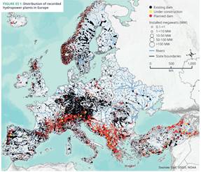
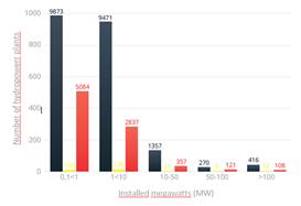
Notes: Left, Distribution of hydropower plants; Right, Distribution of hydropower plants by status and size class.
Source: WWF, 2019
The main types of hydropower plants based on the ability to store water are 1) run-of-river, 2) storage and 3) pumped storage plants. Run-of-river plants are plants without reservoirs, which run on the natural discharge of the river. Storage plants require the construction of a dam and a reservoir to store water. In many regions of Europe, run-of-river plants are the most common type of hydropower plants, but storage and pumped storage plants account for a higher share of the installed capacity.
Figure 10 Images of small hydropower plant (left) and large hydropower plants, storage and run-of-river (centre and right)
Photos not included in TalkBack
Notes: Insert notes here
Sources: 1) By Tangopaso - Own work, Public Domain, https://commons.wikimedia.org/w/index.php?curid=23481491, 2) https://vaw.ethz.ch/en/research/hydraulic-engineering/ethohydraulics.html, 3) https://upload.wikimedia.org/wikipedia/commons/f/fe/Altakraftverket%2C_Norge.jpg
The largest development of hydropower in Europe took place over the last century, harnessing most of the large hydropower potential on the continent. Nonetheless, new hydropower plants are still under development. Several hydropower plants in Europe are under construction (278) and many more are planned to be constructed (8 507). Especially, the Balkans and Turkey have ambitious plans to significantly raise their hydropower exploitation (WWF, 2019). Also, in other parts of Europe, there is an increasing number of applications for new hydropower plants, especially small ones up to 10 MW. For example, in Italy, there are more than 500 requests for new hydropower plants of 1 MW and in Scotland, there have been more than 700 applications for new hydropower development in the last 15 years (Bussettini, 2019; Fyfe, 2019).
Impacts
Hydropower generation causes impacts on aquatic ecology, natural scenery, and ecosystems. The possible key ecological impacts of hydropower are described below (based on ICPDR, 2013).
Hydropower dams and weirs cause an interruption of the longitudinal river continuity. Migrating fish species such as the eel and salmon are particularly affected by the fragmentation of their habitats. In addition, when fish pass through hydropower turbines as they move river downstream, a high proportion of them are injured or killed. The impact of acting as migration barriers is common to most types of hydropower plants.
Furthermore, hydropower plants change river hydromorphology. Hydrological processes and sediment transport lose their natural dynamics leading to altered natural structures and habitats.
Hydropower plants change the river flow regime. In rivers which are impounded for hydropower (typical for storage hydropower plants), flow velocity is reduced which can lead to the loss of orientation of fish. Reduced flow velocity results in other negative impacts such as increased deposition of fine sediment in the impoundment.
Another impact from hydropower results from rapidly changing flows called hydropeaking, which is mainly typical for large hydropower plants in combination with reservoirs. Hydropeaking can cause severe morphological and ecological effects on a river and particularly on fish populations.
Often, at run-of-river hydropower plants, a portion of the river water is diverted e.g. through a canal, to produce energy. This leads to large flow reductions immediately downstream of the river diversion as well as changes in flow patterns further downstream.
Water storage and river regulation through hydropower plants often also alter physical and/or chemical conditions downstream, with changes to water temperature, super saturation of oxygen and altered patterns of ice formation in winter.
Hydropower plants and dams are often not standing alone in a river system, but several can be present on the main river as well as on tributaries. The cumulative effects of multiple hydropower plants, in combination with barriers that do not serve electricity generation, need to be considered (Kampa & Berg, 2020). In a chain of impoundments containing several hydropower plants, the sum total of effects can endanger whole fish populations in a river basin.
Measures and management challenges
In several countries, measures are being implemented to mitigate the impacts of hydropower plants on water bodies. The main measures are targeting upstream fish migration (especially fishways), downstream fish migration (e.g. fish guidance systems and bypasses, fish-friendly turbines), habitat restoration, sediment management as well as the implementation of ecological flows.
Most EU countries have relevant legislation in place to ensure minimum ecological flows and upstream continuity via fishways at hydropower plants. Legislative requirements though are largely missing to address other types of hydropower impacts, such as on downstream fish migration, sediment transport and hydropeaking because of still open questions that need to be addressed by research (Kampa et al., 2011).
Hydropower plants generally operate under a permit/licensing scheme, whereby conditions for the operation are set. However, many hydropower plants were licensed prior to the adoption of key EU water policy such as the WFD in 2000 and national laws protecting rivers. In addition, in many countries, licenses are of unlimited or very long duration (e.g. up to 100 years). The large number of such licenses on old hydropower plants, whose operation conditions are difficult to change, remains a big challenge to the implementation of mitigation measures (Kampa et al., 2017).
Since 2000, the WFD has been a strong driver in modifying the licensing procedures for new hydropower plants and for revising licenses of existing plants in many countries. In case of new hydropower plants, licenses are issued which include requirements for implementing mitigation measures, to comply with national or regional mitigation requirements for hydropower plants.
Also, reconstruction, repowering and application for subsidies is used for introducing ecological demands into the licences. There are plans to reconstruct many existing hydropower plants as a lot of facilities across Europe are more than 40 years old. The reconstruction and modernisation of old hydropower plants can often significantly increase power output and be an alternative to the construction of new plants that would impact further stretches of free-flowing rivers.
Overall, as the energy systems of European countries depend on energy produced via hydropower, we need to find ways to implement measures that mitigate ecological impacts with the least possible effect on energy production for existing and new hydropower plants.
Large-scale strategies for more sustainable hydropower are being developed. Examples include Sweden’s new National Plan for the revision of hydropower licenses in the next 20 years, including a Hydroelectric Environmental Fund for mitigation measures based on industry contributions (SWAM, 2019). Switzerland’s Water Protection Act set mitigation targets for hydropower by 2030, offering financing of mitigation measures via an electricity surcharge (Kampa et al., 2017). Also, at transboundary level, Guiding Principles for Sustainable Hydropower Development have been developed for the international Danube Basin (ICPDR, 2013). At the same time, though, there is a worrying trend of development of many new hydropower plants especially in the Balkans and Turkey and a rising number of applications to develop small new hydropower plants across Europe.
3.2.4 Inland navigation
Overview
Navigation affects most of the major rivers in Europe due to the presence of inland waterways on the large European rivers and intensive leisure boat activity on the smaller rivers. Furthermore, many canals were developed during early industrialisation and some navigable rivers and canal systems are nowadays used for leisure boats only. In order for natural rivers to be used as modern shipping lanes, numerous changes have been made to rivers and their floodplains. Inland navigation is typically associated with a range of hydromorphological alterations such as channelization, channel deepening, channel maintenance, installation of groynes and flow regulation, which adversely impact water ecosystems (BMU/UBA, 2016; ICPDR, 2007). The alterations are bigger when smaller rivers are made navigable for sizes of ships, which are too large for the natural size of the river. In the second RBMPs, a relatively small number of river and lake water bodies (approximately 700 water bodies spread in 13 WFD countries) were reported as impacted by pressures from inland navigation. However, navigation issues are of high importance in some of the largest river basins in Europe such as the Danube and the Rhine.
Navigation intensity has been increasing in Europe since the 1960s both in terms of the volume of transported goods and average vessel size (Graf et al., 2016). Nowadays, there are more than 37 000 kilometres of European inland waterways spanning 20 Member States and connecting hundreds of cities and industrial sites (DG Mobility and Transport, 2019). The uses on inland waterways include navigation for transporting freight, transporting passengers and leisure. Most of the commercial goods transportation by inland ships in Europe concerns five countries: the Netherlands, Germany, France, Belgium and Romania (EC, 2018). More than two-thirds of all goods of European inland waterways are carried on the river Rhine, which is the backbone of inland navigation in Europe (EPRS, 2014). The total volume of goods transported on European inland waterways is approximately 550 million tonnes. However, this equates only to around 6 % (in 2017) of the total volume of all goods transported in the EU (Eurostat, 2019).
In addition, inland waterways are used for water tourism, sports, fishing and angling, and recreational purposes. The recreational water use of navigable rivers can be of great economic significance in certain regions supporting several thousands of jobs in Europe (PIANC et al., 2004).
The infrastructure network of inland waterways includes the natural navigable rivers, artificial-built canals that link navigable rivers, and inland ports. European inland waterways are part of the Trans-European Transport Network (TEN-T) which aims to integrate land, marine, and air transport networks throughout the European Community.
Figure 11 Examples of inland navigation vessels for commercial and recreational purposes
Photos not included in TalkBack
Notes: Insert notes here
Source: https://ec.europa.eu/transport/modes/inland/promotion/naiades2_en; https://www.wikiwand.com/en/River
Impacts
The main impacts from inland navigation on aquatic ecosystems are related to hydromorphological pressures such as the construction of groynes, the protection of river banks with rip-rap, deepening and maintenance of the channel (e.g. via dredging). Altering the shape of river courses to improve navigation affects the characteristics of river beds, river banks and the dynamics of sediment transportation. The effects can spread upstream and downstream over many years. Permanent changes to water levels and flows affect the whole river valley bottom and the ecology of floodplains. Navigation works tend to be designed to stabilise river channels in both space and time, which constrains the natural river dynamics of the river that are important for creating and renewing key habitats (ECMT, 2006). Thus, navigation requirements result in stabilized, ecologically uniform river channels, which lack natural in-stream structures and connectivity with the nearby floodplains (ICPDR, 2007).
Ship traffic also causes waves, which can disturb the reproduction habitats of fish and benthic invertebrates and impact aquatic plants. In addition, the engines of ships can cause an unnatural suspension of fine sediments, leading to reduced light for plant and algae growth (ICPDR, 2007). Further, navigable rivers are usually affected by numerous impoundments to achieve a uniform water level which, at the same time, disrupt river continuity and fish migration.
In addition to hydromorphological impacts, inland navigation can be a potential source of pollution coming from ship waste (oily and greasy ship waste, cargo waste, wastewater and household waste of passenger and hotel ships) or bilge water. There is also a risk of accidental spills, involving oil or hazardous substances, resulting from ship collision or damage (EC, 2018; ICPR, 2015). For example, on the river Rhine, in 2018 and the years before, oil released from shipping was the most frequently reported pollutant among suddenly occurring pollution incidents (ICPR, 2019).
Finally, to maintain navigable water levels in artificial canals that connect different river systems, water is often moved between rivers causing hydrological alterations but also the spreading of invasive alien species. Also, shipping is an important dispersal vector for invasive species between river systems, either by transport at the vessels or by release of bilge water.
Measures and management challenges
In some countries and regions in the EU, such as the international river basins of the Rhine and Danube, actions have been taken or are ongoing to reconcile inland waterway development with river restoration objectives. Key measures to mitigate the impacts of inland navigation on rivers and lakes include the reconstruction of groynes, the removal of hard bank reinforcements and replacement with soft engineering solutions, the re-connection of side arms, floodplains and ox-bows to restore river habitats, as well as the use of more ecologically orientated dredging for maintenance of waterways.
The environmental objectives of the WFD are a major driver for the development of such measures within the RBMPs. In addition, to support the objective of more sustainable inland waterway transport, several European guidelines have been developed indicating good practices for waterway development which is compatible with environmental protection requirements (e.g. PIANC guidelines for sustainable inland waterways and navigation (of 2003), PLATINA Manual on Good Practices in Sustainable Waterway Planning (of 2010)).
Also, the issue of pollution from inland navigation needs to be addressed with appropriate measures. For instance, to deal with pollution and emissions from navigation on the Rhine, a convention on the collection, deposit and reception of waste produced during navigation on the river waterways was adopted in 2009 (ICPR, 2015). Deliberate or accidental losses of pollutants from inland navigation are being recorded in the International Warning and Alarm Plan for the Rhine (ICPR, 2019).
Large-scale strategies for more sustainable inland navigation on national or regional level are being developed. Examples include the ‘Blue Ribbon’ Programme in Germany which aims at creating a system of ecologically re-shaped waterways, by funding the renaturation of federal waterways and their floodplains. The programme focuses on the sections that are no longer needed for cargo shipping (minor waterways) but also implements “ecological stepping stones” in the major waterways (BMU/UBA, 2016). At the transboundary level of the Danube basin, a Joint Statement on Inland Navigation and Environmental Sustainability in the Danube provided principles and criteria for environmentally sustainable inland navigation, including the maintenance of existing waterways and the development of future waterway infrastructure (ICPDR, 2019).
At the same time, though, there may be an increase in inland waterway transport, in view of EU targets to shift part of long-distance road freight to rail and waterborne transport (see Commission White Paper / Roadmap to a Single European Transport Area (EC, 2011)). Future plans for inland navigation in Europe however need to take account of the changing climatic conditions. Intense recent droughts in 2018 led to very low river flows which made parts of major European waterways such as the Rhine and the Danube unnavigable for larger cargo barges.