
Post a comment on the text below
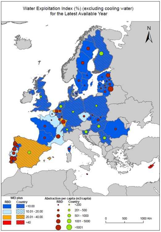
The Water Exploitation Index WEI (defined as the ratio of annual abstraction over long term annual availability (ltaa), see Box 4.1) is used to quantify the pressure (stress) exerted on the environment (i.e. the natural water resources) by anthropogenic activities (i.e. water abstraction).
Map 4.1a Water Exploitation Index WEI and abstraction for European River Basin Districts (latest available year)
Sources: compiled by the ETC/ICM
Notes: Data come from multiple sources, Combination of WISE-SoE#3 and WFD: AT2000-Rhine, AT5000-Elbe, BG1000-Danube Region, BG2000-Black Sea Basin, BG3000-East Aegean, BG4000-West Aegean, SK30000-Vistula, SK40000-Danube / Combination of WISE-SoE#3 and websources: IEGBNISH-Shannon / Websources: ES014-Galician Coast, ES016-Cantabrian, ES020-Duero, ES030-Tagus, ES040-Guardiana, ES050-Guadalquivir, ES07-Segura, ES080-Jucar,ES091-Ebro, ES100-Internal Basins of Catalonia, ES110- Balearic Islands, ES120-Gran Canaria. web link: http://servicios2.marm.es/sia/visualizacion/lda/recursos/superficiales_escorrentia.jsp (*Total water resources in the natural system (hm3/year) Average value for the period between 1941-2009) Reported to DG ENV for the Interim Report: PTRH3, PTRH4, PTRH5, PTRH6, PTRH7, PTRH8 WISE-SoE#3: all other RBDs / Eurostat JQ IWA: all Country level data to be checked on completeness and correctness
You cannot post comments to this consultation because you are not authenticated. Please log in.
Previous comments
For us it is not clear why Austria is not represented in the map. At least AT2000-Rhine and AT5000-Elbe are referenced in the Notes (although the main Austrian RBD AT1000-Danube is not referenced).
However, some data for Austria should be available as the following link to the EEA Homepage shows: http://www.eea.europa.eu/data-and-maps/figures/water-exploitation-index-based-on