
Post a comment on the text below
Box 4.3 The importance of scaling and decoupling in the estimation of water exploitation and water stress
The spatial scale of analysis is essential in the accurate representation of water scarcity conditions. Highly aggregated scales like country level fail to depict the full problem as deficits between water resources availability and demand in one area can be leveraged by surpluses in other areas. Similarly, separating between surface and groundwater resources can further support the assessment of water exploitation. Cases where one of the resources (e.g. groundwater) is overexploited may not appear when availability and abstractions are calculated as sums.
The Greek case of the RDB of Eastern Sterea Ellada (GR07) is a nice illustrative example. The Water Exploitation Index (WEI) calculated based on the long term average availability places
Map 4.2a The WEI for the Greek River Basin District Eastern Sterea Ellada (GR07).
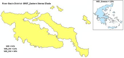
Source: Compiled by the ETC/ICM based on data provided in the Drought and Water Scarcity Management Plan of GR07 (Hellenic Ministry of Environment, Energy and Climate Change and NAMA S.A 2012).
Note: WEI total (31%) and calculated for surface (21%) and groundwater resources (36%) separately, legend: see Map 4.2b, all values in class 20-40%
Map 4.2b The WEI at river basin and subcatchment scale within the Greek RBD Eastern Sterea Ellada (GR07).
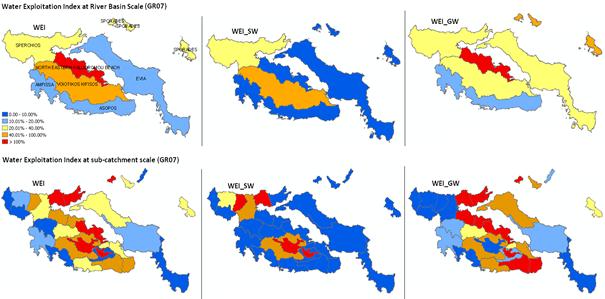
Source: Compiled by the ETC/ICM based on data provided in the Drought and Water Scarcity Management Plan of GR07 (Hellenic Ministry of Environment, Energy and Climate Change and NAMA S.A 2012).
Note: WEI total (left), for surface (middle) and groundwater resources (right) at river basin (top) and subcatchment scale (bottom) within the Greek RBD Eastern Sterea Ellada (GR07).
You cannot post comments to this consultation because you are not authenticated. Please log in.