
Post a comment on the text below
Box 5.7 Flood risk forecasting in Finland
Flood risk assessment and flood control in Finland has been developed in a series of research projects and continuous development work. This has led to the creation of a flood forecasting and warning systems and specific projects for floodwater management.
The basis is a hydrological watershed model system (WSFS) maintained by the Finnish Environment Institute (SYKE). It uses observation and forecasting input from the Finnish Meteorological Institute on weather and combines it with a network of hydrological and meteorological observation points and remote sensing information.
Figure 5.5 Flooding at Vöyrinjoki River in the summer 2004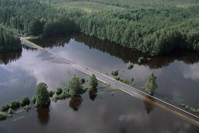
Photo: Unto Tapio
The WSFS is used for flood forecasting, real-time monitoring, nutrient load simulation and climate change research. Hydrological water balance maps are created in real time. Forecasts are made daily for over 500 discharge and water level observation points. Forecasts are used for lake regulation planning and flood damage prevention. The information is available on the internet to public and authorities.
Interactive maps allow users to zoom in on their area of interest. It includes information on hazards by providing, for example, flood and water level warnings and precipitation warnings both for the last 24 hour and 3 day forecasts. Warnings are graded and expressed with colour symbols.
In addition to the warnings the system provides continuously updated information on, for example, runoff, precipitation, snow cover, water equivalent of snow, snow melt, soil moisture deficit and water level. Furthermore nutrient loads are simulated.
For more information see: http://www.environment.fi/floods and http://www.ymparisto.fi/default.asp?contentid=373979&lan=en&clan=en
You cannot post comments to this consultation because you are not authenticated. Please log in.