
Post a comment on the text below
3.3 Hydromorphological pressures
3.3.1 Background
Hydromorphological pressures are assessed as part of the Water Framework Directive, requiring Member States to monitor and manage the effects of changes from physical characteristics on surface water body ecology. Hydromorphological pressures are one of the main reasons for failure to reach good ecological status in European water bodies.
Hydromorphology is a term used in river basin management to describe the hydrological (e.g. water flow) and geomorphological processes and characteristics of surface water bodies, which in combination play a key role for aquatic ecosystems, habitats and species. Good hydromorphological functioning, in particular river-floodplain dynamics, is an essential element of ecosystem health and underpins the delivery of many ecosystem services and benefits for society (EPA Catchments Unit, 2016; Houlden, 2018). Especially river-floodplain dynamics are of high relevance for the development of natural hydromorphological conditions (EEA, 2019c). Hydromorphological pressures include physical changes in natural water bodies to control flow, erosion and floods, as well as land reclamation through drainage and river straightening. These pressures are largely responsible for the widespread loss of wetlands that has occurred in past centuries and are linked to many different human activities, including agriculture, urbanisation, energy production and transport.
The physical impact of agriculture on surface water bodies has to a large extent resulted from drainage needed to increase the area of land with conditions appropriate for crop production, and the need to store water for irrigation (Chapter 2.2.3). Impacts include changes in flow, changes to river banks, riparian zones and floodplains, increased sedimentation and disruption of continuity. Flood protection has been installed across Europe, among others to protect agricultural land from damaging floods.
Agricultural activities such as crop cultivation and livestock production impact floodplains and riparian vegetation, when carried out immediately adjacent to the river or in the floodplain. As a result, the edges of many rivers are directly in contact with agriculture and river floodplains have been fragmented and often reduced to narrow strips or isolated trees on the river banks (REFORM wiki, 2015).
Table 3.2 provides an overview of the key hydromorphological pressures and impacts caused by agricultural activities on water bodies and their surrounding floodplains.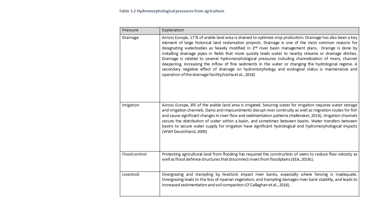
3.3.2 Current status
According to the 2nd river basin management plans (RBMPs), 34% of surface water bodies across the EU are affected by hydromorphological pressures. Hydro-morphological pressures have been identified in almost all Member States, although to a different extent, with some countries having more than 60% of their water bodies affected. In the majority of countries, between 10% and 60% are affected by hydromorphological pressures and only a few countries have reported a share of affected water bodies lower than 10% (EEA, 2018g).
The share of water bodies affected by hydromorphological pressures which are directly linked to agriculture is approximately 7% of total water bodies (EEA, 2018b). The lack of hydromorphological assessment methods and monitoring data appropriate for understanding the nature of hydrological and morphological modifications from agricultural activities, may have led to under estimation of these pressures. Some countries such as Germany, Hungary, Croatia and Spain reported a substantial share of water bodies affected by agricultural hydromorphological pressures, but according to the assessment of the 2nd RBMPs by the European Commission, for most Member States, the identified hydro-morphological pressures have not yet been clearly apportioned to specific sectors (including agriculture) in the WFD reporting (EC, 2019a). Nonetheless, awareness of the importance of hydromorphological pressures and impacts from agriculture is growing.
In addition, drainage for agriculture is the third most common reason for designating water bodies as heavily modified in the EU (having led to the designation of ca. 3,700 out of ca. 18,000 heavily modified water bodies in the 2nd RBMPs), with the highest numbers being designated in Germany and the UK. An additional 1,500 heavily modified water bodies have been designated due to physical modifications of water bodies that serve irrigation, with the highest numbers being designated in Spain, Poland, Italy and Hungary (EEA, 2018a).
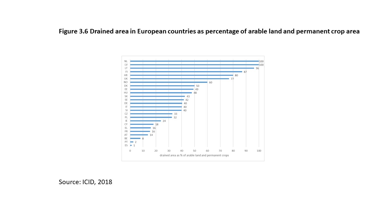
An overview of the proportion of arable land and permanent crops which is drained is shown in Figure 3.6. Drainage occurs in all countries, but with a strong north to south gradient. In the Netherlands, Latvia, Lithuania, and Finland almost all agricultural land is drained (Herzon and Helenius, 2008). In a high number of European countries, more than 40% of farmland is being drained. E.g. in Denmark, 52% of the agricultural area was drained in the 20th century (Møller et al., 2018). Also in other countries with a large area of arable land, the share of drained land is high, e.g. 77% and 40% in the UK and Germany respectively. (see country details in Annex). In southern European countries drainage is lower probably because agriculture in southern Europe is mostly irrigated.
A recent study in Sweden aimed at supporting a national strategy for prioritising measures to improve the water environment in agricultural areas concluded, that a high share of arable land close to water bodies and on their floodplain leads to the impairment of ecologically important structures and functions and degradation of morphology. The result was based on a clustering analysis of sub-basins in Sweden on the basis of agricultural activities. Evidence was provided that sub-basins with a high share of arable land and intensive farming, including livestock, seldom achieve good ecological status while achievement of good ecological status is much more common in sub-basins with a high share of meadows and pastures (Box 3.4)
Box 3.4 Analysis of agricultural impact on hydromorphology in Sweden
In this clustering analysis, 50.800 sub-basins in Sweden were divided into seven groups based on agricultural values. Three of the seven groups (forest, mountainous areas and wet areas) contain three-quarters of all sub-basins but have almost no agriculture. The other four groups are characterized by a high proportion of a certain type of agriculture: intensive farming with special crops, pig production and laying hens (group 2), meadows and pastures (group 3), rural areas with forestry and agriculture (group 4) and intensive farming with cattle and milk production (group 5). Although the total number of sub-basins in groups 2 and 5 constitutes only 2.7% of all Sweden's sub-basins, the majority of Swedish agricultural production is in these sub-basins (77% of all arable land, 91% of land with special crops, 91% of pig livestock and 84% of laying hens in Sweden). The ecological status of water bodies was compared between these different groups.
Source: Swedish Board for Agriculture and Swedish Agency for Marine and Water Management, 2020.
You cannot post comments to this consultation because you are not authenticated. Please log in.