
Table of contents
- Guidance to the reader
- General comments
- Executive summary
- 1. EEA State of Water assessment and EU water policy context
- 2. Ecological status and pressures
- 3. Chemical status and pressures in surface waters
- 4. Groundwater chemical status and pressures
- 5. Groundwater quantitative status and pressures
- 6. Overall status, progress achieved and future challenges
1. EEA State of Water assessment and EU water policy context
1. EEA State of Water assessment and EU water policy context
Key messages
- The Water Framework Directive requires EU Member States to achieve good status in all bodies of surface water and groundwater, in principle by 2015. Achieving good status involves meeting certain standards for the ecology, chemistry, and quantity of waters.
-
it is suggested that
......Achieving good status involves meeting certain standards for the ecology, chemistry, and quantity of waters.
to be changed into
...... Achieving good status involves meeting certain standards for the biology, chemistry, and hydromorphology of waters.
-
Some information that might be useful for this Chapter: Information for some MS you might find useful, also supporting our arguments for changing some of the text on reasons for status of EU waters (as outlined above): - DE (only 64% of GW in good status; 8% of SW in GES; 100% of surface water are failing to achieve good chemical status); - ES ((1) cca 2% of the SW bodies are of unknown ecological status; up to 5% of the SW bodies in unknown chemical status; GW bodies are said to be all monitored, and there are 25% failing to achieve good quantitative status and 35% failing to achieve good chemical status. (2) No monitoring, with the exception perhaps of the Duero basin, has taken place in the last years regarding hymo parameters. (3) Some progress made regarding the update or completion of pressures inventory; however no progress made in understanding better the relationship between pressures-impact and status. (4) Most of the 1st RMBPs/PoM measures have not been fully implemented, thus no results as regards improvement in WBs status could be estimated). - RO (from the 1st to the 2nd cycle RO simply downgraded the status of about a hundred WBs from high ecological status to good, so there is now 1 WB in high status; that should be taken into account in presenting the results).
- The data reported for the second River Basin Management Plans (RBMPs) show that the quantity and quality of available evidence on status and pressures has grown significantly due to significant investments by Member States in monitoring and assessment. As an indication, surface waters and groundwaters have been monitored at over 130 000 monitoring sites over the past six years.
- This has resulted in markedly improved RBMPs, providing a better understanding of the ecological, chemical and quantitative status, the pressures causing failure to achieve good status, and the required measures.
- The EU Member States have reported status and pressures for 13 400 groundwater bodies and 111 000 surface water bodies: 80 % of them are rivers, 16 % lakes and 4 % coastal and transitional waters.
- The delineation of about 90 % of the surface water bodies were unchanged from the first to the second RBMPs. Around 70 % of the groundwater bodies (by area) were not changed.
- The results in this report present a European overview of the data reported by the second RBMPs and the status and pressures affecting Europe's waters. Caution is needed when comparing results between Member States and between first and second RBMPs, as the results can be significantly affected by the methodology applied by individual Member States.
-
This part can be elaborated further. We know more about the status of water in the RBMPs for 2015-2021 than from 2009-2015. This makes it very difficult to compare data and assess the water bodies in the two planning cycles.
-
We aggree with the Danish comment. For instance in Hungary the number of the WBs with "unknown status" has decreased in the second planning period which have affected the overall status of the WBs.
1.1 Background
The main aim of the European Union’s (EU) water policy is to ensure that a sufficient quantity of good quality water is available for people's needs and for the environment. Since the first water directives in the 1970s the EU has worked to create an effective and coherent water policy. The Water Framework Directive (WFD)[1], which came into force in 2000, establishes a framework for the assessment, management, protection and improvement of the quality of water resources across the EU. In addition, objectives for water from the European Union's 7th Environment Action Program (7th EAP)[2], together with those from its Biodiversity Strategy 2020 and the 'Blueprint to safeguard Europe's water resources', are key components to maintain and improve the essential functions of Europe's water-related ecosystems including coastal and marine areas, and to ensure they are well managed.
Since December 2015, EU Member States have been publishing the second River Basin Management Plans (RBMPs) for achieving the environmental objectives of the WFD. They are an update of the first RBMPs, which were published in 2009. In 2018, the European Commission will publish its report on the assessment of the second RBMPs. The Commission has also started the process of evaluating the Water Framework Directive[3], with the publication of the Roadmap for the Fitness Check on the Water Framework Directive and the Floods Directive[4]. To accompany and inform this process and to fulfil the requirement of WFD Article 18[5], the EEA has produced this report on the 'State of Europe's water' along with presentation of more detailed WFD results in WISE.
The report aims to present results on:
- What is the status of EU waters based on the second RBMPs?
- Which pressures are causing less than good status?
- What progress has been achieved during the first RBMP cycle (2009-2015)?
The report presents results on the status of surface waters and groundwater in Europe, providing overviews at EU level, Member State and River Basin Districts (RBDs).
Chapter 1 introduces the EU water policy context and sets the frame for the state of water assessments. It addresses the data sources and geographical scope of the report, provides an overview of water bodies, as well as heavily modified and artificial water bodies. The chapter also describes the specific challenges of comparing the data from the first and the second RBMP and the constraints that need to be taken into account.
Chapter 2 to 5 deal with the status assessments of surface waters (ecological status and chemical status) and of groundwater (chemical status and quantitative status). These chapters follow a common narrative. Each chapter introduces the particular status assessment, describes the status of EU waters in second RBMPs, looks into the pressures that are causing less than good status and then compares the status in the first and second RBMPs.
Chapter 6 brings the results together in an analysis of drivers, pressures and impacts and provides an overview of the improvements achieved since the first RBMPs. It addresses the main pressures responsible for not (yet) achieving good status in all European waters. The chapter discusses in more detail pollution from point and diffuse sources and its relationship to water quality, and how habitats have been altered and hydrology modified due to water abstraction. The chapter concludes with an outlook into the future: What will be status in 2021, 2017 and beyond? and challenges in water management.
-
last sentence: "What will be status in 2021, 2017 and beyond? and challenges in water management."
2027 instead of 2017. Please change.
-
it is suggested that
........The Water Framework Directive (WFD), which came into force in 2000, establishes a framework for the assessment, management, protection and improvement of the quality of water resources across the EU.
to be changed into
........The Water Framework Directive (WFD), which came into force in 2000, establishes a framework for the assessment, management, protection and improvement of the status quality of water resources across the EU.
-
it is suggested that the below sentence part be clarified -it is about reviewing process of WFD?
.....The Commission has also started the process of evaluating the Water Framework Directive,....
-
"Since December 2015, EU Member States have been publishing the second River Basin Management Plans (RBMPs) for achieving the environmental objectives of the WFD. They are an update..."
They are even more than an update. A better wording would be "further development".
-
"The report aims to present results on:
- What is the status of EU waters based on the second RBMPs?
- Which pressures are causing less than good status?
- What progress has been achieved during the first RBMP cycle (2009-2015)?"
Only the first bullet point is the main aim of this report (Art. 2b). This draft report hardly includes measures, pressures and progress.
-
BE-WAL (EC): p. 12 §6
The date is not 2017 but 2027
Assessing status of water
EU Member States should aim to achieve good status in all bodies of surface water and groundwater by 2015 unless there are grounds for derogation. Only in this case may achievement of good status be extended to 2021 or by 2027 at the latest. Achieving good status involves meeting certain standards for the ecology, chemistry and quantity of waters. In general, 'good status' means that water shows only a slight change from what would normally be expected under undisturbed conditions. There is also a general 'no deterioration' provision to prevent deterioration in status. An overview of assessment the status of surface waters and groundwater according to the WFD is illustrated in figure 1.1.
Ecological status of the WFD assesses ecosystem health expressed by biological quality elements: phytoplankton, macrophytes, phytobenthos, benthic invertebrate fauna, and fish, supported by hydromorphological and physico-chemical parameters: nutrients, oxygen condition, temperature, transparency, salinity, and river basin specific pollutants (RBSPs). The Directive specifies which elements are to be assessed for each water category, and requires that all biological elements and supporting quality elements achieve at least good status.
The WFD aims to ensure good chemical status of both surface water and groundwater bodies across Europe. For surface waters, this goal is defined by limits on the concentration of certain pollutants relevant across the EU, known as priority substances. Good chemical status means that the concentrations of all priority substances do not exceed the environmental quality standards (EQS) established in the Environmental Quality Standards Directive 2008/105/EC and amended by the Priority Substances Directive 2013/39/EU[6]. EQS are set to protect the most sensitive species, including humans via secondary poisoning.
Good groundwater chemical status is achieved when there is no saline intrusion in the groundwater body, when concentrations of specified substances do not exceed relevant standards, and does not result in failure to achieve good status of associated surface water bodies, nor cause significant damage to terrestrial ecosystems which depend directly on the groundwater body[7].
Figure 1.1. Assessment of status of surface waters and groundwater according to the WFD
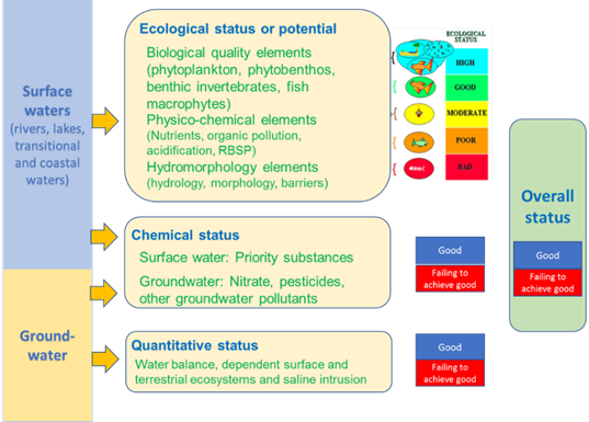
Good groundwater quantitative status is achieved by ensuring that the available groundwater resource is not exceeded by the long-term annual average rate of abstraction[8]. Accordingly, the level of groundwater may not lead to any diminution of ecological status of connected surface waters or any diminution of groundwater dependent terrestrial ecosystems. Furthermore, reversals of flow direction may not result in saline or other intrusions.
-
“EU Member States should aim to achieve good status in all bodies of surface water and groundwater by 2015 unless there are grounds for derogation. Only in this case may achievement of good status be extended to 2021 or by 2027 at the latest.”. This is not correct and not in line with the documents approved by WD in 2017. A “derogation” (please avoid this word and use exemption, as derogation has to be requested (Nitrate Directive), while exemption has to be motivated in plans) is also possible beyond 2027, in case it can be motivated within WFD art 4.4.c.
-
“Good chemical status means that the concentrations of all priority substances do not exceed the environmental quality standards (EQS) established in the Environmental Quality Standards Directive 2008/105/EC and amended by the Priority Substances Directive 2013/39/EU”. This suggests that PSD2013 should have been applied in 2015. This is the case for NL (and I believe SW and LUX), but most countries used only PSD2008. This is correctly explained at p. 19. Please avoid misunderstanding, with the text on p. 13.
-
1. "Good groundwater chemical status is achieved when there is no saline intrusion in the groundwater body, when concentrations of specified substances do not exceed relevant standards, and does not result in failure to achieve good status of associated surface water bodies, nor cause significant damage to terrestrial ecosystems which depend directly on the groundwater body11. "
The sentence is very complex / complicated. Rephrase, please.
&
Please change "does not" in "do not".
2. The presentation of the ecological status / potential in figure 1.1 is to our opinion misleading.
a) There is no visible differentiation between biological quality elements and supporting physiical and chemical quality elements (including hydromorphology). As in Germany and to our knowledge in most MS the ecological status / potential is determined by the biological quality elements only. The physical and chemical quality elements (including hydromorphology) are only used supportive. Please change figure 1.1 accordingly.
b) The figure 1.1 contains a green field called "overall status". Basically the WfD consists for surface waters of a "ecological status /potential" and a "chemical status". Both have to be in at least "good status" - if not, measures are necessary in order to reach the good status/potential.
But the WfD contains no "overall status" per definition and the MS`s do also not report such an "overall status" to the EU- Commission. Therefore we recommend to delete the green box "overall status" from this figure.
-
The figure 1.1 is not 100% in line which the provisions of the WFD.
Ecological potential: The ecological potential classification only distinguishes 4 classes and these should be added to this figure.
Groundwater: According to the WFD groundwater quantitative and chemical status is good or poor but not ”failing to achieve good”. Besides the colour-code for good status is green and not blue.
Overall status: The WFD does not foresee such a status.
-
BE-FLA (RV): p. 12-13 All biological elements
This is an important requirement and the degree this is met should be reflected in the analysis.
-
"In general, 'good status' means that water shows only a slight change from what would normally be expected under undisturbed conditions." Does this imply no human activity?
-
"The Directive specifies which elements are to be assessed for each water category, and requires that all biological elements and supporting quality elements achieve at least good status."
This is wrong. There are no exact values for hydromorphology to achieve a good status or potential. Actually, even the classification guidance document includes the case when biological quality elements achieve a good status and physico-chemical elements do not, then modifying class boundaries of physico-chemical quality elements shall be considered.
-
It should be made clear in the Figure 1.1 that phy-chem and hydromorphology are not at the same level as BQE, but only constitute supporting elements.
-
(AT): Figure 1.1
AWB/HMWB Ecological potential is not mentioned at all. Ecological potential classes have to be included in the graph – only 4 classes are used for presenting potential (high does not exist), differnt coulour code is used (green/grey stripes,...)
-
Degoration--> term exceptions is used in WFD art.4
-
"Ecological status of the WFD assesses ecosystem health expressed by biological quality elements: phytoplankton, macrophytes, phytobenthos, benthic invertebrate fauna, and fish, supported by hydromorphological and physico-chemical parameters: nutrients, oxygen condition, temperature, transparency, salinity, and river basin specific pollutants (RBSPs)."
It is not clear how the RBSPs were assessed in the context of ecological status, and how the factors (biological diversity and hydromorphological) ranked when compared to physico-chemical analysis. It seems that RBSP are basically treated like Priority Substances, e.g. when failing the EQS, the whole water body will not achieve ‘good ecological status’. It may be helpful to have evidence of how many water bodies fail ecological status based on the biology and hydromorphology. We are concerned that the disproportionate attention paid to RBSP, and to metals in particular, is due in part to their natural occurrence, the easy and cheap methods for their detection, and possibly to the bias in sampling near areas of concern, which will unsurprisingly show high concentrations of metal. To our understanding, the evaluation of the ecological status and the causative factors explaining less than good ecological status on the one hand, and the management approaches that are considered to improve ecological status on the other hand are somehow disconnected. The analysis shows that a major source of deterioration of ecological status is “hydromorphological pressure”. However, there seems to be an assumption that improving chemical status alone will improve ecological status, and so that is the focus. And metals become the sub-focus because they are indeed easy to measure. But even if all waters show good chemical status, good ecological status will be difficult to attain because of impacts of non-contaminant stressors.
-
Please, add the following to the end of the 2nd Para :
"The results of the ecological status assessment can be significantly affected by the methodology applied by individual Member States."
Justification: the assessment methods in Member States, the practical use of CIS Guidance No. 13. e.g.: combination of quality elements ("one out all out" principle), the criteria of confidence (high, medium, low, not known) or that, how many biological quality elements and indicative quality element for pressures were monitorized in given waterbody give large variable picture among MSs. All this information could establish and give reasonable knowledge to compare results in consistent way. The impact of pressures all this above mentioned reasons could be describe in more cases in quality element level only and not in ecological status level. -
PLease change the right part of Fig 1.1, since the "overall status" does not exist in the WFD
Status classification up to 2012/13
The second RBMPs generally show status classification up to 2012/13 and at that time, many measures were only in the process of implementation. With this in mind, the impact of the measures from the first RBMPs may be expected to be small. It takes time to turn plans into changes on the ground. It also takes time for changes on the ground to come through in monitoring results. This is partly due to lag times in the recovery of plant and animal communities and groundwater response times and partly because some status assessments are based on combining monitoring results collected over a number of years.
-
Please delete "up to 2012/13" in the title as this is not the case for all MS. In Luxembourg we have used, whenever possible, monitoring data up to 2015 for the status assessment.
-
BE-FLA (RV): p. 14, §1 Number of years
... collected over a number of years: of which the maximum is the reporting period interval
-
New boundaries have been established for some groundwater bodies. New methods are also being used. The sentence "partly because some status assessments are based on combining monitoring results collected over a number of years" needs to be explained.
Significant pressures and impacts
Europe's waters are affected by several pressures, including water pollution, water scarcity, droughts and floods. Major physical modifications to water bodies also affect morphology and water flow.
The WFD requires the identification of significant pressures from point sources of pollution, diffuse sources of pollution, modifications of flow regimes through abstractions or regulation and morphological alterations, as well as any other pressures. ‘Significant’ is interpreted as meaning that the pressure contributes to an impact that may result in the failing of Article 4(1) Environmental Objectives (of not having at least good status or potential).
The identification of significant pressures and their resulting impacts (which in turn lead to a reduced status) can involve different approaches: field surveys, inventories, numerical tools (e.g. modelling), expert judgement or a combination of tools.
Figure 1.2. For water bodies in less than good status the significant pressures and pollutants should be identified.
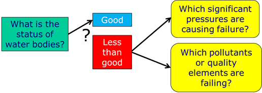
By now, many of the several thousand individual measures in the first RBMPs are completed. However, some measures are not fully completed yet mainly due to funding constraints, while other measures have been difficult to implement.
|
Further and detailed information on WFD and second RBMPs · European Commissions homepage on WFD Link · Main reports on progress in the implementation of the WFD since the adoption of the first River Basin Management Plans <a web page with overview of relevant Commission, JRC and EEA reports on implementation of WFD> Commissions WFD reports Link; JRC and EEA · Overview of RBMPs Link – Link2. Further and detailed information on assessing status of waters is available in · Commissions Water Notes Link · CIS guidance documents Link · WFD reporting guidance CIS Guidance No. 21; EC, 2009; and 2016 see http://cdr.eionet.europa.eu/help/WFD/WFD_521_2016 |
-
Sentence 3:
The bit in brackets "(of not having at least good status or potential)" suggests that significant pressures only refer to ecological status, what about chemical status?
Please change.
-
Figure 1.2: Please add an arrow in figure 1.2: from the green box to the red box.
-
BE-FLA (RV): p. 14, §3 Significant pressure
To be included: explanation on combined pressures (in the case each pressure in itself is not a significant pressure)
-
BE-FLA (RV): p. 14, §6 Individual measures
"many" should be quantified, as measures are an important element of the RBMPs
-
"Europe's waters are affected by several pressures, including water pollution, water scarcity, droughts and floods. Major physical modifications to water bodies also affect morphology and water flow."
Physical modifications are necessary, otherwise there would be no flood security. They also enable agriculture, energy, transport, etc. Additionally, there are strict laws and counter-measures to keep impacts at a minimum.
-
"The WFD requires the identification of significant pressures from point sources of pollution, diffuse sources of pollution, modifications of flow regimes through abstractions or regulation."
Which kind of regulation? Flood protection measures?
-
Figures 1.1 and 1.2 are both misleading. Fig. 1.1. implies that supporting elements have the same status as classifying elements
Fig. 1.2. gives a wrong message, which is also seen in the text: If the status is less than a good status, then the next step is to check if this is due to physical alteration needed for specific use etc.
Both figures should be modified in order to better reflect the WFD
-
Stakeholders must not be blamed for not implementing mitigation measures in case MS fail to provide funding. A clear sharing of responsibilities is needed. Further, it should be pointed out that some stakeholders at least try to do their best (hydro) while others have not even started to set any measures.
-
(AT) Figure 1.2
The graph does not really reflect the DPSIR approach!
The analysis of significant pressures and the risk assessment is the basis for monitoring and status assessment (not only needed for WB failing good status)
It would be better to include the DPSIR-circle!
-
SK: The title of Figure 1.2 has a form of sentence. The correct title is missing.
1.2 Data sources, geographical coverage, and methodology
This report is compiled from information on the status of European surface water and groundwater bodies as reported by the EU Member States into the Water Information System for Europe (WISE). In summer 2017, 25 Member States had reported into WISE. The WISE-WFD database includes data from the first and second RBMPs. The reporting of WFD data is based on the Common Implementation Strategy (CIS) Reporting Guidance, which has been revised in 2016[9].
The implementation of the WFD has resulted in the designation of 180 RBDs across the EU, and 31 international RBDs. RBMPs have been produced for all the RBDs. Each of the RBMPs consists of many different documents, maps and datasets. The main RBMP document that often is 200-300 pages long provides detailed information on status and pressures affecting the designated water bodies, monitoring programmes and the Programme of Measures to be implemented during the new management cycle. In addition, RBMPs often include several appendixes and in some cases, Member States have established interactive map services or information systems to provide detailed information for the individual water bodies.
This report only presents key results, while more detailed WFD results are presented in an interactive tool in WISE. The following chapters include small text boxes with links to more detailed information (see examples below)
|
Further and detailed information on delineation of RBDs and water bodies is in WISE · Surface water bodies: Number and Size; Number or Size, by Category · Groundwater bodies: Number and Size |
The WISE visualisation tool is being further developed during the consultation period, and updated versions of some of the tables and graphs will be produced. EEA will regularly upload two files (one with links to tables and one with links to graphs) to the consultation folder.
https://forum.eionet.europa.eu/nrc-eionet-freshwater/library/2018-state-water-consultation-1
-
We suggest to delete "that often is 200-300 pages long" and "RBMPs often include several appendixes and".
Surface water and groundwater bodies
In the context of the WFD, the 'water environment' includes rivers, lakes, transitional waters, groundwater and coastal waters out to one nautical mile (12 nautical miles for chemical status (i.e. territorial waters). These waters are divided into units called water bodies.
The EU Member States now have reported 13 400 groundwater bodies and 111 000 surface water bodies: 80 % of them are rivers, 16 % lakes and 4 % coastal and transitional waters (Table 1.1). All Member States have reported river and groundwater bodies. 23 Member States (all reporting Member States except Luxemburg and Slovakia) have reported lake water bodies, 14 Member States have reported transitional water bodies and 20 reported coastal water bodies. In the second RBMPs seven Member States have delineated 46 territorial waters i.e. water bodies from 1-12 nautical mile.
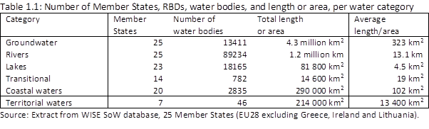
The number of water bodies varies considerably between Member States due to the size of their territory but also due to their approach to delineate water bodies. Sweden has by far the largest number of surface water bodies, followed by France, Germany, United Kingdom and Italy. Sweden and Finland show the highest number of lake water bodies. Coastal water bodies are the most numerous in Italy, Sweden and United Kingdom.
A similar disparity can be seen for groundwater bodies. France reported 30 % of the total groundwater area in the EU, and Germany and Spain 9 % each. Groundwater bodies can occur in different horizons, and some groundwater bodies overlay others. The average size of groundwater bodies also differs significantly. In Sweden and Finland, the average area is 7 km2, while in the other Member States the average area is nearly 700 km2.
Some Member States have re-delineated some of their water bodies for the second RBMPs. About 90 % of the surface water bodies are unchanged from the first to the second RBMPs. About 10 % have either been deleted, markedly modified (split or aggregated) or newly created. In most of countries, there were only minor changes in number and length/area of surface water bodies but in some Member States water body delineation has been completely revised and replaced by new groundwater surface water bodies.
The area of reported groundwater bodies was nearly the same for the first and the second RBMPs. Around 70 % of the groundwater bodies (by area) were not changed, while 29 % of the groundwater bodies from the first RBMPs were deleted and replaced by new groundwater bodies.
In the comparison of results from the first and second RBMPs EEA has in general only compared those water bodies that are unchanged or have only minor changes that do not hamper the comparison. For water bodies that have been deleted, aggregated, split or newly created, a comparison is not possible.
|
Further and detailed information on delineation of RBDs and water bodies is available in WISE: · Map RBMPs and relevant RBD statistics (update of 2012 map) · Surface water bodies: Number and Size; Number or Size, by Category · Groundwater bodies: Number and Size · Comparison of delineation of water bodies first and second RBMP: surface water bodies* · WISEevolutiontype – change in delineation of WBs: surface water bodies Link (details Link) and groundwater bodies Link (details Link) · CIS Guidance Document No. 2: Identification of Water Bodies Link |
* draft dashboards;
-
First sentence: Please add another bracket at the end of the sentence: "....one nautical mile (12 nautical miles for chemical status (i.e. territorial waters)). "
-
"In Sweden and Finland, the average area is 7 km2, while in the other Member States the average area is nearly 700 km2." should be replaced as follows "In Sweden and Finland, the average area is 7 km2, while in other Member States the average area exceeds 1.000 km2."
-
"The number of water bodies..."
There are many differences among Member States regarding the setting of length of their surface water bodies. Therefore, benchmarking is quite difficult. For example: AT 2,7 km versus other big hydro countries FI, FR, SW, ES etc. approx. 10-12 km. However, there are not only difficulties in performing benchmark analyses but also in setting the "right" scale for measures.
-
"Map RBMPs and relevant RBD statistics (update of 2012 map)"
Ther is mistakes in that map. Finland has reported only two International River Basin Districts:
Tornionjoki IRBD (shared with Sweden)
Teno, Näätämöjoki and Paatsjoki IRBD (shared with Norway) -
In the Table "Surface water bodies: Number and Size":
the length of the HU river water bodies is incorrect: it is not 19 313 km, but correctly 19 126 km and
the area of the HU lake water bodies is incorrect: it is not 1 017 km², but correctly 1 180 km². -
"Table 1.1: Number of Member States, RBDs, water bodies, and length or area, per water category"
The total number of waterbodies (not including groundwater) in Table 1.1 (n=111062) differ from the total number stated in the Table ’Surface water bodies: Number and Size’ table (n=110950).
-
Better explanation of substantial differencies between member states GWB areas would be appreciated. In the meaning: Groundwater body area varies a lot from one member state to another because of between-states differences in the definition of the water bodies. Some countries have a simple 1-layer definition, sometimes restricted to the waterbodies providing drinking water. Some other countries such as France have a more accurate definition, including several depth layer. The former can have a reported GWB cumulated area lower than the country's geographical surface, while the latter can report a GWB cumulated area up to twice the country's geographical surface. For the next evaluation, it would be necessary to advance in homogenisation of GWB definition to ensure the relevance of between-countries comparisons (for exemple: decreasing the proportion of GWB areas/geographical surface for member states well covered and its increasing for anothers; using for exemple the boundaries of 0.8 to 1.4 )
-
p. 16 "The average size of groundwater bodies also differs significantly. In Sweden and Finland... 700 km2." We want to add that the reason is geological since the majority of the Nordic groundwaters are glaciofluvial.
-
Many Tables, maps and summary statistics to be updated.
-
"France reported 30 % of the total groundwater area in the EU, and Germany and Spain 9 % each." This very high figure for France is probably justified by the fact that to improve monitoring and management, FR has considered a large number
of horizons (whereas some countries have a simple 1-layer definition, perhaps even limited to drinking water supply)).
A clear comment is necessary to explain these figures / these discrepancies.
Designation of heavily modified and artificial water bodies
In the case of water bodies that have undergone hydromorphological alteration, the WFD allows Member States to designate some of their surface waters as Heavily Modified Water Bodies (HMWBs) or Artificial Water Bodies (AWBs).
In many river basins, the upper stretches in mountainous areas, highland areas, and often in forest areas remain largely in their natural state except when hydropower and irrigation reservoirs have changed the system. However, lower stretches, often passing large cities and intensive agricultural land, are modified by embankments and other public works. These areas are usually designated as heavily modified waters. Other examples of heavily modified water bodies are rivers with flood defenses, inland waterways, and reservoirs on rivers, or lakes. Heavily modified transitional and coastal water have often been altered by land reclamation or dredging due to urban, transport, and agricultural developments.
Overall, 17 % of European water bodies were designated as HMWBs (13 %) or AWBs (4 %) during the second RBMPs. Around 30 % of the transitional water bodies were designated as heavily modified and 14 % and 10 % of the river and lake water bodies, respectively.
Artificial water bodies can include canals, reservoirs or open-cast mining lakes. More than 6 % of lakes and around 4 % of river water bodies have been identified as artificial. However, only a few of the transitional and coastal waters are listed as being AWBs.
The main reasons for designating European water bodies as heavily modified are land drainage, urban infrastructure, agriculture, but also water regulation and flood protections.
|
Further and detailed information on designation of natural, heavily modified and artificial water bodies is available in WISE: · Designation of natural, heavily modified and artificial water bodies, Number or Size, by Category and Type · HMWB physical alterations Table* · HMWB water uses Table* · CIS Guidance Document Heavily modified water bodies – HMWB Link |
-
In reference to "open-cast mining": in the Aggregates Industry, it is possible to create wetlands during and after the extraction phases, in accordance with the permit granted by the administration (including environment and water management authorities, and in many cases under the EIA scheme). Most of those new wetlands or lakes are designed according to suitable hydromorphological parameters, to achieve a new (artificial) water body that is able to grant water quality parameters and biodiversity requirements for their life time. Some of them have flood protection designs or even good quality water supply to urban areas for human consumption. In the European Union, a vast majority of aggregates extraction sites are dealing with inert materials such as sand, gravel and crushed rock, and produce inert wastes according to EU definitions and criteria included in EU Directives. The industry’s production process does not include the use of chemicals and therefore does not represent a threat for water quality. It is necessary to make a clear distinction between the concept of mining and quarrying, as the nature of their activities and the properties of the materials they extract are very different. It is therefore essential to define clearly in the report what is meant by heavy industry or mining. As mining sites counting for less than 5% in comparison with quarries, sand and gravel extraction sites representing 95%, it would be recommended to clearly define which measures apply to mining and which ones to the Aggregates Industry rather than addressing the entire extractive industry.
-
The sentence: “In many river basins, the upper stretches in mountainous areas, highland areas, and often in forest areas remain largely in their natural state except when hydropower and irrigation reservoirs have changed the system” is a bit a caricature: Of course, in these areas, today’s situation is quite often linked to the history of regional development including periods of industrialization and urbanization of high valleys. Hydropower and irrigation reservoirs do have changed the system BUT are only two of many influencing elements of the past. In many river basins, the upper stretches in mountainous-, highland- or forest areas remain largely in their natural state. In some cases these areas have to be modified with the aim to ensure security of population, enable infrastructure or generate power. Proposal: "reservoirs for irrigation and hydropower" would be better wording.
-
(AT) 1st sentence: '...some of their surface waters...'
Better explanation is needed -> reference to Art. 4 (3)
Separate category -> Ecological potential instead of status
Following graphs include only status, separate graphs needed for HMWB/AWB.
Improvements in monitoring and assessment
The data reported for the second RBMPs shows that the quantity and quality of available evidence on status and pressures has grown significantly due to significant investments into monitoring and assessment. This has resulted in markedly improved RBMPs providing a better understanding of the status (ecological, chemical and quantitative status), the pressures causing failure to achieve good status, and the needed measures.
Surface waters and groundwater have been monitored at over 130 000 monitoring sites over the past six years (Table 1.2). The number of surface water monitoring sites, quality elements and pollutants assessed have increased relative to the first management cycle (see following status chapters).
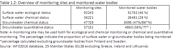
There is a marked reduction in unknowns and improved confidence in assessment in the second RBMPs. For surface water bodies the proportion in unknown ecological status and chemical status fell from 16 % to 4 % and from 39 % to 16 %, respectively, while for groundwater bodies, the proportion in unknown chemical status and quantitative status decreased to only 1 %.
The confidence in the status assessments[10] has also improved. In the first RBMPs Member States reported fewer than one third of surface water bodies' ecological status with high or medium confidence, while in the second RBMPs this has improved to half of the water bodies. The confidence in surface water body chemical status is relatively low compared to the other status assessments, with only 41 % of the water bodies in the second RBMPs having high or medium confidence. The confidence in groundwater chemical and quantitative status assessments is good with two thirds of the water bodies having high or medium confidence.
Higher confidence is also ensured through intercalibration[11] of ecological status with the number of intercalibrated biological assessment methods that has generally increased three-fold since 2008 making results much more comparable than for the first RBMPs (see chapter 2).
|
Further and detailed information on monitoring and assessment is available in WISE: · Overview of monitoring statistics – (Table & maps) · Ecological status - Monitoring sites Tables* & Monitored water bodies Tables* & percentage of classified water bodies using different quality elements. (missing – see Figure 2.1) · Quality elements – monitored, grouping or expert judgement Table* - Graph* · RBSPs (pollutants monitored, threshold values) (missing) · SWB Chemical status - (2nd RBMP) Monitoring sites, by purposeMS*, CategoryPurposeEU*, categoryPurposeMS* (2nd RBMP) Monitored water bodies purposeMS*, CategoryPurposeEU*, categoryPurposeMS* · Groundwater monitoring (missing) · Surface water bodies: unknown ecological status and unknown chemical status · Groundwater unknown GW chemical status and GW quantitative status · Confidence in: ecological status assessment Table and Graph*; SWB chemical status assessment Table and Graph*; GW chemical status assessment Table and Graph* and GW quantitative status assessment Table and Graph* · CIS Guidance Document on monitoring: No. 7: Monitoring; No. 15 Groundwater monitoring; No 19 - Surface water chemical monitoring; and No 25 - Chemical Monitoring of Sediment and Biota Link |
* draft dashboards;
-
Please define what you consider to be unknown: “Surface water bodies: unknown ecological status and unknown chemical status”. What if not all but only a x% of the chemicals have been assessed in a water body? What if no biological q.e. (and only one/more supporting elements) has been assessed for the ecological status? This in relation to the statement on p. 13. “and requires that all biological elements and supporting quality elements achieve at least good status.”, suggesting that good status can only be assigned when all biological elements have been assessed (which is of course not the same as ‘monitored’). At p. 21, it is concluded: “On a European scale, around 40 % of the surface water bodies are in good or high ecological status,.. ”. Does that mean that in at least around 40 % of the surface water bodies all biological elements and supporting quality elements are assessed?
-
BE-FLA (VVDL): p. 17 Improvements in monitoring and assessment
BE agrees with the comment made by NL.
-
BE-FLA (KB-VVDL): p. 17, footnote #14 Confidence according to Guidance
See reporting guidance
Confidence ecological data : Low = no monitoring data; Medium = supporting QE data and/or limited data on one BQE; High = good data for at least one BQE and the most relevant supporting QE.
Confidence chemical data : Low = no monitoring data; Medium = limited or insufficiently robust monitoring data for some or all Priority Substances that are discharged in the RBD; High = good data for all Priority Substances that are discharged in the RBD.
Please, explain ‘confidence’ in the report.
-
What is a monitoring site in this context? One that is reported as an etablished monitoring site or as a water body where data has been reported from. Please specify.
-
please see reporting guidance - in terms of the confidence of ecological data the following are indicated : Low; Medium,High and "0" (which means No information).
So the option Unknown has not been provided in the guidance document.
-
"There is a marked reduction in unknowns and improved confidence in assessment..."
Due to unclear basic knowledge of the ecological status, many problems cannot be addressed with best-fitting measures. It is important not to set obligations for implementing measures in cases without any profound data/knowledge.
-
"The confidence in the status assessments has also improved."
Whose confidence? Benchmarking?
-
Regarding the Ecological status - Monitoring sites tables, there are differences between figures from Romania WISE database and EEA Report: No mon sites MS, No monSites cat_MS (only for RW), No mon WBs MS, No mon WBs_MS_Cat (only for RW).
The same comments for SWB Chemical status - (2nd RBMP) Monitoring sites tables: SWB chemMon -2nd RBMP no of monitoring sites, SWB chemMon -2nd RBMP no of WB, SWB chemMon -2nd RBMP category no of monitoring sites (only for RW), SWB chemMon WBs -2nd RBMP no of WB (only for RW).
-
BE-WAL (EC) p. 17 ref14
Remind in the charts for a better understanding “Low= no monitoring data; Medium = limited or insufficiently robust monitoring data; and High = good monitoring data and good understanding of the system”
-
CZ: Table 1.2: Make more clear reason for exclusion of SE and FI GWBs i.e. large number of very small GWBs compare to the rest of EU.
-
Second paragraph, 'over 130 000 monitoring sites...': It would be good for the reader to indicate whether this is a lot or not enough; similarly as % in the table below.
1.3 Assessment methodologies
The results in this report present a European overviews of the data reported by the second RBMPs and the status and pressures affecting Europe's waters. Caution is advised for Member State comparisons and comparison between first and second RBMPs, as the results are affected by the methodological approach used by the individual Member States. The following text describes some issues that may affect the interpretation of results.
Difficulties in assessing change from the first to the second RBMPs
Comparisons between the two RBMPs are difficult for several reasons. Firstly, the WFD Reporting Guidance was significantly revised and extended in 2016. There have been many changes in how Member States implement the Directive, e.g. water body re-delineation and improvement of assessment methods. Some of the issues relevant for the understanding of this report are discussed below.
-
First paragraph: Maybe this text could also be included in the introductory part (even in a footnote) and reflected in the statements on the status made therein.
Status classification up to 2012/13
The second RBMPs generally show status classification up to 2012/13 and at that time many measures were only in the process of being implemented. Lag times in the recovery of plant and animal communities and groundwater response times can also cause long delays in recovery of status after pressures have been reduced. With this in mind, the impact of the measures from the first RBMPs on the status reported in the second RBMPs may be expected to be small.
-
Please delete "up to 2012/13".
Comparability of overall status assessments
The WFD objectives for all water bodies are expressed as overall good water status, encompassing both chemical and ecological status for surface waters and chemical and quantitative status for groundwater. Each of these status assessments includes a number of quality elements/-determinants. The WFD uses the “one-out-all-out” principle in assessing water bodies (i.e., the worst status of the elements used in the assessment determines the overall status of the water body).
If only the overall status assessment or the aggregated status (ecological and chemical) are used, the progress achieved in some quality elements/determinants may be hidden by the lack of progress in others. This may result in an overly pessimistic view on the progress achieved by WFD implementation, in particular for those Member States, which have more developed, and comprehensive assessment schemes, which include many elements. In some cases, the lack of development of assessment methods in the first cycle, or from incomplete intercalibration may also have made the results from the first RBMPs less confident.
-
First sentence:
Please change the content of this sentence - no "overall good status" is reported to the EU-Commission. The WfD does not contain a "overall good status" per definition. According to the WfD each water body need to be in "good ecological status / potential" and in "good chemical status".
-
"If only the overall status assessment or the aggregated status (ecological and chemical) are used, the progress achieved in some quality elements/determinants may be hidden by the lack of progress in others."
Please change the content of this sentence - no "overall good status" is reported to the EU-Commission. The WfD does not contain a "overall good status" per definition. According to the WfD each water body need to be in "good ecological status / potential" and in "good chemical status".
-
Please delete the word "overall" in the title.
-
"The WFD objectives for all water bodies are expressed as overall good water status, encompassing both chemical and ecological status for surface waters and chemical and quantitative status for groundwater." should be replaced as follows "The WFD objectives for all water bodies are expressed as good water status, encompassing both chemical status and ecological status/potential for surface waters and chemical and quantitative status for groundwater."
-
"The WFD uses the “one-out-all-out” principle in assessing water bodies (i.e., the worst status of the elements used in the assessment determines the overall status of the water body). If only the overall status assessment or the aggregated status (ecological and chemical) are used, the progress achieved in some quality elements/determinants may be hidden by the lack of progress in others." should be replaced as follows "The WFD uses the “one-out-all-out” principle in assessing water bodies (i.e., the worst status of the elements used in the assessment determines the overall status of the water body) and the progress achieved in some quality elements/determinants may be hidden by the lack of progress in others."
-
- Second paragraph, first sentence: See our comments above on ’one-out-all-out’ the report should be more caution and not give an impression that this principle is problematic, which it now does.
- Second paragraph, second sentence: However, it would also be important to explain that methods used by MS rarely respond very specifically to hydromorphological pressures. To be sure that hydromorphological pressures and their effects do not remain undetected, it is therefore very important to use of hymo classification methods alongside the BQEs.
In this report, the results of the overall ecological and chemical status assessments are supported by the analysis of status assessments at the level of quality elements or individual pollutants. Caution should be made in using the results for Member State comparisons. The Member States’ results depend on the monitoring activities and the number of quality elements used or chemicals assessed. The results have to be interpreted together with the results on confidence in status and the details on quality elements and chemicals and their threshold values.
Full implementation of standards for chemical status assessment
The Directive 2008/105/EC on Environmental Quality Standards (EQS Directive 2008/105/EC)[12] is fully in force for the second RBMPs and means stricter standards for some priority substances compared to the first RBMPs. The Directive also requires Member States to report an inventory of emissions, discharges and losses in their second RBMPs.
During our analysis, it has become clear that Member States have used a variety of approaches to determine chemical status, for instance,
- In how they extrapolate monitoring results. Several Member States (Austria, Belgium, Germany, Sweden, Luxembourg and Slovenia), having found that the environmental quality standard for mercury is exceeded in all monitoring samples, have extrapolated the assessment “failing to achieve good” to all surface water bodies.
- Using different standards for chemical status. According to the WFD2016 reporting guidance, Member States should have reported chemical status for 2015 using the standards laid down in the EQS Directive 2008/105/EC, but some Member States have reported chemical status by using the stricter standards in the 2013 amendment to the Priority Substances Directive.
As regards the Groundwater Directive, the assessment of trends of pollutants in groundwater will be possible for the first time in the second RBMPs, by comparing the monitoring results with the results in the first RBMPs.
-
last sentence:
Please replace "will be" by "are" or "were".
(Why future tense is used here?)
-
In Luxembourg the EQS for the sum Benzo(g,h,i)-perylene + Indeno(1,2,3-cd)-pyrene was systematically exceeded and therefore we assumed that the chemical status was ”failing to achieve good” status in all surface water bodies.
-
(AT) end of 2nd bullet point '.. Priority Substances Directive.'
Include reference to Directive 2013/39/EU
-
SK: Page 19, 4th paragraph: Use official reference via Eur-lex: http://eur-lex.europa.eu/legal-content/EN/TXT/?qid=1517936846370&uri=CELEX:32008L0105 as a reference for EQSD in footnote.
-
SK: Page 19, second bullet: We are not sure whether the English is correct in the sentence ”... amendment to the Priority Substance Directive. We suppose that there should be written ”...amendment by Priority Substance Directive” because Directive 2013/39/EU have not been amended yet. On the contrary, the Directive 2008/105/EC (EQSD) was amended in 2013 by directive 2013/39/EU (Priority Substance Directive).
-
SK: Page 19, 6th paragraph: Add reference on Groudwater Directive, as a 2006/118/EC (http://eur-lex.europa.eu/legal-content/EN/TXT/?qid=1517937438209&uri=CELEX:32006L0118).
-
p. 19 We suggest to slightly reformulate "Using different standards for chemical status. According to the WFD 2016 reporting guidance, Member States should have reported... Priority Substances Directive". This sounds like the countries that used stircter standards limits have made wrong. We followed our legislation and current directive of priority substances and were unable to reclassify about 20,000 water bodies for reporting. We propose:
Using different standards for chemical status. Some Member States applied the revised, generally stricter, EQS set out in the 2013 amendment to the Priority Substances Directive while most countries used those from the 2008 version of the Directive and also according to the WFD2016 reporting guidance.
Changes in reporting requirements in 2010 and 2016
Besides the changes mentioned above, reporting of the second RBMPs also brings new elements into play: some due to legislation, which was not fully in force at the time the first RBMPs were adopted; others due to the fact that the second RBMPs can be compared with the first RBMPs, thereby allowing assessments of progress towards objectives.
Some of these new elements relevant for the State of Water assessments are listed below (extract from CIS Reporting Guidance). They provide possibilities for new assessments, but results cannot be compared to first RBMPs.
Text Box 1.1: Key changes in the Reporting Guidance between first and second RBMP
|
Heavily modified water bodies: · Report the water use and type of physical modification, for which the HMWB has been designated. Pressures and impacts: · Use new list of drivers, pressures and impacts common for surface and groundwater. Ecological status: · Provide status information at the more detailed quality element (QE) level (including reference year). · Provide information on the change in class since the first RBMP was reported, if available. Changes in class should be reported as consistent (i.e. real) or as due to changes in methodology, e.g. monitoring and/or assessment methods. · Report the River Basin Specific Pollutants (RBSP) causing failure. Surface water chemical status: · Report failure of individual substances. · Provide a qualitative indication of the confidence in the chemical status assessment. · Indicate the substances that have improved from poor to good chemical status since the first RBMP was reported. · Indicate if the more stringent EQSs introduced in 2013 for 7 substances change the status of water bodies. Groundwater chemical status: · Report individual substances causing failure to chemical status. · Provide a qualitative indication of the confidence in the classification of quantitative and chemical status (optional). · Report substances showing exceedance of quality standards or threshold values but not assessed as chemical status failures, i.e. cases in which Article 4(2)c of the GWD apply. Objectives and exemptions: · Report whether the water body is expected to achieve good status in 2015 and if not, by when. · Report the drivers behind exemptions at water body level for ecological status and groundwater quantitative status, at substance level for surface water and groundwater chemical status. |
Sources/footnotes
[1] EC 2000, Directive 2000/60/EC of the European Parliament and of the Council of 23 October 2000 establishing a framework for Community action in the field of water policy. http://eur-lex.europa.eu/legal-content/EN/TXT/?uri=CELEX:32000L0060
[2] EC (2014), The 7th Environment Action Programme (EAP). http://ec.europa.eu/environment/action-programme/
[3] WFD article 19, 2. The Commission will review this Directive at the latest 19 years after the date of its entry into force and will propose any necessary amendments to it.
[4] https://ec.europa.eu/info/law/better-regulation/initiatives/ares-2017-5128184_en
[5] WFD Article 18: The EU Commission shall publish a report on the implementation of the directive two years after the Member States have delivered the RBMPs. The report shall include a review of the status of surface water and groundwater in the Community undertaken in coordination with the European Environment Agency (EEA)
[6] http://ec.europa.eu/environment/water/water-dangersub/pri_substances.htm
[7] http://ec.europa.eu/environment/water/water-framework/groundwater/framework.htm
[8] http://ec.europa.eu/environment/water/water-framework/groundwater/framework.htm
[9] CIS Guidance No. 21; EC, 2009; and 2016 see http://cdr.eionet.europa.eu/help/WFD/WFD_521_2016
[10] The CIS Reporting Guidance defines confidence as Low = no monitoring data; Medium = limited or insufficiently robust monitoring data; and High = good monitoring data and good understanding of the system.
[11] EC 2008: Water Note 7: Intercalibration: A common scale for Europe's waters http://ec.europa.eu/environment/water/participation/pdf/waternotes/water_note7_intercalibration.pdf
[12] http://ec.europa.eu/environment/water/water-dangersub/pri_substances.htm
-
footnote: WFD Article 18: This is not the text of Art. 18! In fact, the EEA is only in charge of Art. 2 b) (together with EC)
-
"Some of these new elements relevant for the State of Water assessments are listed below (extract from CIS Reporting Guidance). They provide possibilities for new assessments, but results cannot be compared to first RBMPs."
It is important not to stick to the old version. The main goal is not to make the 2 reports comparable but to depict as good as possible the status of water bodies. An ongoing adjustment also of reporting is natural. Make also clear that WFD goals are a long-term vision that cannot be reached within a few years.
"The Water Framework Directive requires EU Member States to achieve good status in all bodies of surface water and groundwater, in principle by 2015." could be replaced as follows "The Water Framework Directive requires EU Member States to achieve good status in all bodies of surface water and groundwater by 2015 unless there are grounds for exemption."